
Dane County topographic map
Interactive map
Click on the map to display elevation.
About this map
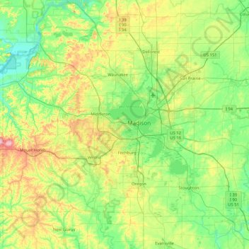
Name: Dane County topographic map, elevation, terrain.
Location: Dane County, Wisconsin, United States (42.84515 -89.83857 43.29416 -89.00883)
Average elevation: 289 m
Minimum elevation: 218 m
Maximum elevation: 477 m
Other topographic maps
Click on a map to view its topography, its elevation and its terrain.
Town of Geneva
United States > Wisconsin > Walworth County
Town of Geneva, Walworth County, Wisconsin, 53147, United States
Average elevation: 296 m
Kickapoo Valley Reserve
United States > Wisconsin > Vernon County > La Farge
Kickapoo Valley Reserve, S3661, State Highway 131, La Farge, Town of Whitestown, Vernon County, Wisconsin, 54639, United States
Average elevation: 318 m
Town of Oshkosh
United States > Wisconsin > Winnebago County
Town of Oshkosh, Winnebago County, Wisconsin, United States
Average elevation: 236 m
Endeavor
United States > Wisconsin > Marquette County
Endeavor, Marquette County, Wisconsin, United States
Average elevation: 242 m
Coomer
United States > Wisconsin > Burnett County
Coomer, Town of La Follette, Burnett County, Wisconsin, United States
Average elevation: 308 m
Dodgeville
United States > Wisconsin > Iowa County
Dodgeville, Iowa County, Wisconsin, United States
Average elevation: 369 m
Amery
United States > Wisconsin > Polk County
Amery, Polk County, Wisconsin, United States
Average elevation: 330 m
Juneau County
Juneau County, Wisconsin, United States
Average elevation: 302 m
Waterloo
United States > Wisconsin > Jefferson County
Waterloo, Jefferson County, Wisconsin, United States
Average elevation: 257 m
Minocqua
United States > Wisconsin > Oneida County
Minocqua, Town of Minoqua, Oneida County, Wisconsin, United States
Average elevation: 491 m
King Park
United States > Wisconsin > Milwaukee County > Milwaukee
King Park, Milwaukee, Milwaukee County, Wisconsin, United States
Average elevation: 204 m
Governor Dodge State Park
United States > Wisconsin > Iowa County
Governor Dodge State Park, Town of Dodgeville, Iowa County, Wisconsin, 53533, United States
Average elevation: 336 m
Town of Grand Chute
United States > Wisconsin > Outagamie County
Town of Grand Chute, Outagamie County, Wisconsin, United States
Average elevation: 245 m
Murry
United States > Wisconsin > Rusk County
Murry, Town of Murry, Rusk County, Wisconsin, United States
Average elevation: 355 m
Hillsboro
United States > Wisconsin > Vernon County
Hillsboro, Vernon County, Wisconsin, United States
Average elevation: 307 m
LaValle Mill Pond
United States > Wisconsin > Sauk County > Village of La Valle
LaValle Mill Pond, Village of La Valle, Town of La Valle, Sauk County, Wisconsin, United States
Average elevation: 292 m
Wonewoc
United States > Wisconsin > Juneau County
Wonewoc, Juneau County, Wisconsin, United States
Average elevation: 305 m
Meehan
United States > Wisconsin > Portage County
Meehan, Town of Plover, Portage County, Wisconsin, United States
Average elevation: 323 m
Red Cliff
United States > Wisconsin > Bayfield County > Red Cliff
Red Cliff, Town of Russell, Bayfield County, Wisconsin, 54814, United States
Average elevation: 215 m
Town of Nepeuskum
United States > Wisconsin > Winnebago County
Town of Nepeuskum, Winnebago County, Wisconsin, United States
Average elevation: 258 m
Gordons Bay
United States > Wisconsin > Crawford County
Gordons Bay, Town of Eastman, Crawford County, Wisconsin, United States
Average elevation: 236 m
Town of Mount Morris
United States > Wisconsin > Waushara County
Town of Mount Morris, Waushara County, Wisconsin, United States
Average elevation: 274 m
Appleton
United States > Wisconsin > Outagamie County > Appleton
Appleton, Outagamie County, Wisconsin, United States
Average elevation: 240 m
Wrightstown
United States > Wisconsin > Brown County > Wrightstown
Wrightstown, Brown County, Wisconsin, 54180, United States
Average elevation: 199 m
Cedar Creek
United States > Wisconsin > Ozaukee County
Cedar Creek, Ozaukee County, Wisconsin, 53202-3519, United States
Average elevation: 250 m
Fish Creek
United States > Wisconsin > Door County > Fish Creek
Fish Creek, Town of Gibraltar, Door County, Wisconsin, 54212, United States
Average elevation: 189 m
Hudson
United States > Wisconsin > Saint Croix County > Hudson
Hudson, Saint Croix County, Wisconsin, 54016-9303, United States
Average elevation: 242 m
Dells of the Wisconsin River State Natural Area
United States > Wisconsin > Sauk County > Wisconsin Dells
Dells of the Wisconsin River State Natural Area, Wisconsin Dells, Town of Dell Prairie, Sauk County, Wisconsin, United States
Average elevation: 282 m
Green Bay
United States > Wisconsin > Brown County > Green Bay
Green Bay, Brown County, Wisconsin, United States
Average elevation: 199 m
Marshfield
United States > Wisconsin > Wood County
Marshfield, Wood County, Wisconsin, 54449, United States
Average elevation: 382 m
Ashland County
United States > Wisconsin > Ashland County
Ashland County, Wisconsin, United States
Average elevation: 324 m
Eau Claire
United States > Wisconsin > Eau Claire County
Eau Claire, Eau Claire County, Wisconsin, United States
Average elevation: 274 m
Cooper Park
United States > Wisconsin > Milwaukee
Cooper Park, Milwaukee, Milwaukee County, Wisconsin, United States
Average elevation: 227 m
Town of Delafield
United States > Wisconsin > Town of Delafield
Town of Delafield, Waukesha County, Wisconsin, United States
Average elevation: 291 m
Hilbert
United States > Wisconsin > Calumet County
Hilbert, Calumet County, Wisconsin, United States
Average elevation: 258 m
Lake Adelade
United States > Wisconsin > Vilas County > Town of Winchester
Lake Adelade, Town of Winchester, Vilas County, Wisconsin, United States
Average elevation: 508 m
Kimberly
United States > Wisconsin > Outagamie County
Kimberly, Outagamie County, Wisconsin, 54136, United States
Average elevation: 225 m
Johnson Creek
United States > Wisconsin > Jefferson County
Johnson Creek, Jefferson County, Wisconsin, 53038, United States
Average elevation: 249 m
Tennyson
United States > Wisconsin > Grant County
Tennyson, Grant County, Wisconsin, United States
Average elevation: 282 m
Hunter Island
United States > Wisconsin > Wisconsin Rapids
Hunter Island, Wisconsin Rapids, Wood County, Wisconsin, 54494, United States
Average elevation: 330 m
Marathon County
Marathon County, Wisconsin, United States
Average elevation: 398 m
Alderley
United States > Wisconsin > Alderley
Alderley, Town of Ashippun, Dodge County, Wisconsin, United States
Average elevation: 297 m
Sheboygan County
Sheboygan County, Wisconsin, United States
Average elevation: 255 m
Hatley
United States > Wisconsin > Hatley
Hatley, Marathon County, Wisconsin, United States
Average elevation: 393 m
Racine
United States > Wisconsin > Racine County > Racine
Racine, Racine County, Wisconsin, United States
Average elevation: 188 m
Julia Creek
Julia Creek, Town of Three Lakes, Oneida County, Wisconsin, 54562, United States
Average elevation: 502 m
Egg Harbor
United States > Wisconsin > Egg Harbor > Egg Harbor
Egg Harbor, Door County, Wisconsin, United States
Average elevation: 194 m
Schofield
United States > Wisconsin > Marathon County
Schofield, Marathon County, Wisconsin, United States
Average elevation: 364 m
Walworth County
Walworth County, Wisconsin, United States
Average elevation: 282 m