
Make a donation
Gear up for your next adventure:
As an Amazon Associate, this site earns from qualifying purchases at no extra cost to you.
South Carolina topographic map
Click on the map to display elevation.
Make a donation
Gear up for your next adventure:
As an Amazon Associate, this site earns from qualifying purchases at no extra cost to you.
South Carolina
South Carolina's topography is defined by three major geographic regions: the Atlantic Coastal Plain, the Piedmont, and the Blue Ridge Mountains. Covering approximately two-thirds of the state, the Atlantic Coastal Plain is characterized by flat, gently rolling terrain that transitions from the sandy beaches along the Atlantic Ocean to swamps and estuaries further inland. The coastal areas are interspersed with barrier islands and unique features like Carolina bays—elliptical depressions formed by various geological processes. Moving inland, the Piedmont region features rolling hills and elevated plateaus, with elevations generally ranging from 400 to 1,200 feet (122 to 366 meters), and includes the distinctive fall line where the rivers descend to the lower coastal plain. The northwest corner of the state rises into the Blue Ridge Mountains, with Sassafras Mountain as the highest point at 3,560 feet (1,085 meters). This area is known for its rugged terrain, steep slopes, and rich biodiversity. Overall, South Carolina's diverse topography reflects a rich geological history influenced by ancient mountains, river systems, and coastal dynamics.
Make a donation
Gear up for your next adventure:
As an Amazon Associate, this site earns from qualifying purchases at no extra cost to you.
About this map
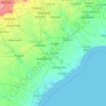
Name: South Carolina topographic map, elevation, terrain.
Location: South Carolina, United States (32.03345 -83.35400 35.21549 -78.54135)
Average elevation: 85 m
Minimum elevation: -4 m
Maximum elevation: 1,642 m
Make a donation
Gear up for your next adventure:
As an Amazon Associate, this site earns from qualifying purchases at no extra cost to you.
Other topographic maps
Click on a map to view its topography, its elevation and its terrain.
Little Saint James Island
United States > United States Virgin Islands > Saint Thomas - Saint John District
Average elevation: 1 m
Mendenhall Glacier
United States > Alaska > Juneau
The two small parking lots have access to several trails in the area. Photo Point Trail and the Steep Creek Trail are easy and accessible trails. Elevated boardwalks above Steep Creek provide salmon and bear viewing opportunities. Visitors can hike via the East Glacier Loop to an overlook within 1 mile (1,600…
Average elevation: 974 m
Make a donation
Gear up for your next adventure:
As an Amazon Associate, this site earns from qualifying purchases at no extra cost to you.
Make a donation
Gear up for your next adventure:
As an Amazon Associate, this site earns from qualifying purchases at no extra cost to you.
Make a donation
Gear up for your next adventure:
As an Amazon Associate, this site earns from qualifying purchases at no extra cost to you.
Mount Rainier
United States > Washington > Pierce County
Mount Rainier (/reɪˈnɪər/ ray-NEER), also known as Tahoma, is a large active stratovolcano in the Cascade Range of the Pacific Northwest in the United States. The mountain is located in Mount Rainier National Park about 59 miles (95 km) south-southeast of Seattle. With a summit elevation of 14,399.6 ft…
Average elevation: 3,912 m
Grand Mere State Park
United States > Michigan > Berrien County > Stevensville
Average elevation: 185 m
Make a donation
Gear up for your next adventure:
As an Amazon Associate, this site earns from qualifying purchases at no extra cost to you.
Fort Bragg
United States > California > Mendocino County
Fort Bragg is a city along the Pacific Coast of California along Shoreline Highway in Mendocino County. The city is 24 miles (39 km) west of Willits, at an elevation of 85 feet (26 m). Its population was 6,983 at the 2020 census.
Average elevation: 8 m
Monument Valley
United States > Arizona > Navajo County
The area is part of the Colorado Plateau. The elevation of the valley floor ranges from 5,000 to 6,000 feet (1,500 to 1,800 m) above sea level. The floor is largely siltstone of the Cutler Group, or sand derived from it, deposited by the meandering rivers that carved the valley. The valley's vivid red color…
Average elevation: 1,675 m
Make a donation
Gear up for your next adventure:
As an Amazon Associate, this site earns from qualifying purchases at no extra cost to you.
Lisbon
United States > Florida > Lake County
Lisbon has low rolling landscape with elevations ranging from 30 ft to 60 ft.
Average elevation: 23 m
Make a donation
Gear up for your next adventure:
As an Amazon Associate, this site earns from qualifying purchases at no extra cost to you.
Make a donation
Gear up for your next adventure:
As an Amazon Associate, this site earns from qualifying purchases at no extra cost to you.
Denali's Fault. Scenic overlook
United States > Alaska > Unorganized Borough > Delta Junction
Average elevation: 379 m
Make a donation
Gear up for your next adventure:
As an Amazon Associate, this site earns from qualifying purchases at no extra cost to you.
Make a donation
Gear up for your next adventure:
As an Amazon Associate, this site earns from qualifying purchases at no extra cost to you.
Make a donation
Gear up for your next adventure:
As an Amazon Associate, this site earns from qualifying purchases at no extra cost to you.
Make a donation
Gear up for your next adventure:
As an Amazon Associate, this site earns from qualifying purchases at no extra cost to you.
Make a donation
Gear up for your next adventure:
As an Amazon Associate, this site earns from qualifying purchases at no extra cost to you.
Make a donation
Gear up for your next adventure:
As an Amazon Associate, this site earns from qualifying purchases at no extra cost to you.
Make a donation
Gear up for your next adventure:
As an Amazon Associate, this site earns from qualifying purchases at no extra cost to you.
Sanlando Springs
United States > Florida > Seminole County > Altamonte Springs
Average elevation: 25 m
Make a donation
Gear up for your next adventure:
As an Amazon Associate, this site earns from qualifying purchases at no extra cost to you.
Bozrah Veterans Memorial
United States > Connecticut > Southeastern Connecticut Planning Region > Fitchville
Average elevation: 78 m
South Woodstock
United States > Connecticut > Northeastern Connecticut Planning Region
Average elevation: 136 m
Make a donation
Gear up for your next adventure:
As an Amazon Associate, this site earns from qualifying purchases at no extra cost to you.
Picking Conservation Land East
United States > Massachusetts > Middlesex County > Westford
Average elevation: 73 m
Make a donation
Gear up for your next adventure:
As an Amazon Associate, this site earns from qualifying purchases at no extra cost to you.
Make a donation
Gear up for your next adventure:
As an Amazon Associate, this site earns from qualifying purchases at no extra cost to you.
Glenmoore Local Open Space
United States > Maryland > Baltimore County > Cockeysville
Average elevation: 121 m
Short Hills
United States > New Jersey > Essex County > Millburn > Short Hills
Average elevation: 98 m
Make a donation
Gear up for your next adventure:
As an Amazon Associate, this site earns from qualifying purchases at no extra cost to you.
Make a donation
Gear up for your next adventure:
As an Amazon Associate, this site earns from qualifying purchases at no extra cost to you.
Make a donation
Gear up for your next adventure:
As an Amazon Associate, this site earns from qualifying purchases at no extra cost to you.
Orange Grove Estates
United States > South Carolina > Charleston County > Charleston
Average elevation: 4 m
Make a donation
Gear up for your next adventure:
As an Amazon Associate, this site earns from qualifying purchases at no extra cost to you.
Make a donation
Gear up for your next adventure:
As an Amazon Associate, this site earns from qualifying purchases at no extra cost to you.
Make a donation
Gear up for your next adventure:
As an Amazon Associate, this site earns from qualifying purchases at no extra cost to you.
Three Sisters
United States > Arizona > Navajo County
Monument Valley is part of the Colorado Plateau. The elevation of the valley floor ranges from 5,000 to 6,000 feet (1,500 to 1,800 m) above sea level. The floor is largely siltstone of the Cutler Group, or sand derived from it, deposited by the meandering rivers that carved the valley. The valley's vivid red…
Average elevation: 1,667 m
Make a donation
Gear up for your next adventure:
As an Amazon Associate, this site earns from qualifying purchases at no extra cost to you.