
Grayson County topographic map
Interactive map
Click on the map to display elevation.
About this map
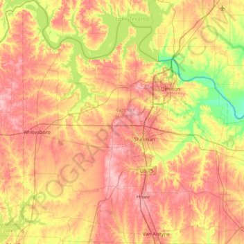
Name: Grayson County topographic map, elevation, terrain.
Location: Grayson County, Texas, United States (33.39789 -96.94507 33.95835 -96.37940)
Average elevation: 214 m
Minimum elevation: 147 m
Maximum elevation: 276 m
Other topographic maps
Click on a map to view its topography, its elevation and its terrain.
San Antonio
United States > Texas > Bexar County
San Antonio, Bexar County, Texas, United States
Average elevation: 247 m
Lake Whitney State Park
United States > Texas > Hill County
Lake Whitney State Park, Hill County, Texas, United States
Average elevation: 165 m
McLean
United States > Texas > Gray County
McLean, Gray County, Texas, 79057, United States
Average elevation: 873 m
Midlothian
United States > Texas > Ellis County
Midlothian, Ellis County, Texas, 76065, United States
Average elevation: 212 m
Frisco
United States > Texas > Collin County
Frisco, Collin County, Texas, United States
Average elevation: 201 m
Canton
United States > Texas > Van Zandt County
Canton, Van Zandt County, Texas, 75103, United States
Average elevation: 159 m
South Lake
United States > Texas > Hill County
South Lake, Hill County, Texas, United States
Average elevation: 189 m
Allen
United States > Texas > Collin County
Allen, Collin County, Texas, United States
Average elevation: 200 m
Converse
United States > Texas > Bexar County
Converse, Bexar County, Texas, 78109, United States
Average elevation: 223 m
Duke
United States > Texas > Fort Bend County > Arcola
Duke, Arcola, Fort Bend County, Texas, 77545, United States
Average elevation: 20 m
Plano
United States > Texas > Collin County
Plano, Collin County, Texas, United States
Average elevation: 196 m
Soil Conservation Service Site 12 Dam
United States > Texas > Williamson County > Type
Soil Conservation Service Site 12 Dam, Type, Williamson County, Texas, United States
Average elevation: 173 m
El Paso
United States > Texas > El Paso County
El Paso, El Paso County, Texas, United States
Average elevation: 1,237 m
Elsa
United States > Texas > Hidalgo County
Elsa, Hidalgo County, Texas, 78543, United States
Average elevation: 22 m
Bayview
United States > Texas > Cameron County
Bayview, Cameron County, Texas, United States
Average elevation: 7 m
Willow Grove
United States > Texas > McLennan County
Willow Grove, McLennan County, Texas, 76702, United States
Average elevation: 169 m
Moran
United States > Texas > Shackelford County
Moran, Shackelford County, Texas, United States
Average elevation: 411 m
Sun Valley
United States > Texas > Lamar County
Sun Valley, Lamar County, Texas, United States
Average elevation: 166 m
Cleveland
United States > Texas > Liberty County
Cleveland, Liberty County, Texas, 77327, United States
Average elevation: 47 m
Seymour
United States > Texas > Baylor County
Seymour, Baylor County, Texas, 76380, United States
Average elevation: 401 m
Carrizo Springs
United States > Texas > Dimmit County
Carrizo Springs, Dimmit County, Texas, 78834, United States
Average elevation: 185 m
Crystal City
United States > Texas > Zavala County
Crystal City, Zavala County, Texas, 78839, United States
Average elevation: 174 m
Lubbock
United States > Texas > Lubbock County
Lubbock, Lubbock County, Texas, United States
Average elevation: 983 m
Omen
United States > Texas > Smith County
Omen, Smith County, Texas, 75750, United States
Average elevation: 135 m
Horseshoe Bay
United States > Texas > Llano County
Horseshoe Bay, Llano County, Texas, 78657, United States
Average elevation: 290 m
Signal Hill
United States > Texas > Williamson County
Signal Hill, Williamson County, Texas, United States
Average elevation: 291 m
Dublin
United States > Texas > Erath County
Dublin, Erath County, Texas, 76446, United States
Average elevation: 451 m
Mayhill
United States > Texas > Denton County > Denton
Mayhill, Denton, Denton County, Texas, 76208, United States
Average elevation: 183 m
Canturbury Trails Park
United States > Texas > Travis County > Austin
Canturbury Trails Park, Austin, Travis County, Texas, United States
Average elevation: 210 m
Carpenters Bluff
United States > Texas > Grayson County
Carpenters Bluff, Grayson County, Texas, United States
Average elevation: 165 m
Lake Cooper
United States > Texas > Archer County
Lake Cooper, Archer County, Texas, United States
Average elevation: 357 m
Mount Wesley
United States > Texas > Kerr County > Kerrville
Mount Wesley, Kerrville, Kerr County, Texas, 78029, United States
Average elevation: 533 m
Georgetown
United States > Texas > Williamson County
Georgetown, Williamson County, Texas, United States
Average elevation: 247 m
Valley View
United States > Texas > Cooke County
Valley View, Cooke County, Texas, United States
Average elevation: 222 m
Camp Mountain
United States > Texas > Upshur County
Camp Mountain, Upshur County, Texas, 75640, United States
Average elevation: 132 m
Meadow
United States > Texas > Terry County
Meadow, Terry County, Texas, United States
Average elevation: 1,015 m