
Shanghai topographic map
Interactive map
Click on the map to display elevation.
Shanghai
The golden age of Shanghai began with its elevation to municipality after it was separated from Jiangsu on 7 July 1927. This new Chinese municipality covered an area of 494.69 km2 (191.0 sq mi), including the modern-day districts of Baoshan, Yangpu, Zhabei, Nanshi, and Pudong, but excluded the foreign concessions territories. Headed by a Chinese mayor and municipal council, the new city government's first task—the Greater Shanghai Plan—was to create a new city center in Jiangwan town of Yangpu district, outside the boundaries of the foreign concessions. The plan included a public museum, library, sports stadium, and city hall, which were partially constructed before being interrupted by the Japanese invasion. In the 1920s, shidaiqu became a new form of entertainment and was popularised in Shanghai.
About this map
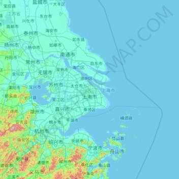
Name: Shanghai topographic map, elevation, terrain.
Location: Shanghai, China (30.66931 118.60018 33.44314 123.33421)
Average elevation: 13 m
Minimum elevation: -3 m
Maximum elevation: 1,435 m
Other topographic maps
Click on a map to view its topography, its elevation and its terrain.
Shanghai
The golden age of Shanghai began with its elevation to municipality on 7 July 1927. This new Chinese municipality covered an area of 494.69 km2 (191.0 sq mi), including the modern-day districts of Baoshan, Yangpu, Zhabei, Nanshi, and Pudong, but excluded the foreign concessions territories. Headed by a Chinese…
Average elevation: 5 m
Cho Oyu
China > Tibet > Tingri County
Cho Oyu's height was originally measured at 26,750 feet (8,150 m) and at the time of the first ascent it was considered the 7th highest mountain on earth, after Dhaulagiri at 8,167 metres (26,795 ft) (Manaslu, now 8,156 metres (26,759 ft), was also estimated lower at 26,658 feet (8,125 m)). A 1984 estimate of…
Average elevation: 7,339 m
Chongqing
The central urban area of Chongqing, or Chongqing proper, is a city of unique features. Built on mountains and partially surrounded by the Yangtze and Jialing rivers, it is known as a "mountain city" and a "city on rivers". The night scene of the city is very illuminated, with millions of lights and their…
Average elevation: 318 m
Yingjiang County
China > Yunnan > Yingjiang County
Yingjiang county is mountainous with several alluvial plains. The county has various climate types, with ranges from the tropical, the subtropical, to the temperate zones. Intact forests can be seen in the mountains above 2,000 m (6,600 ft). The elevations vary from 210 to 3,404.6 m (689 to 11,170 ft).
Average elevation: 1,428 m
Hezuo
China > Gansu > Hezuo City
With an elevation of nearly 3,000 metres (9,800 ft), Hezuo has an alpine subarctic climate (Köppen Dwc), with long, very cold, dry winters, and short, mild summers. The monthly daily mean temperature in January, the coldest month, is −9.3 °C (15.3 °F), while the same figure for July, the warmest month, is…
Average elevation: 3,199 m
Guangzhou City
China > Guangdong > Guangzhou City
The elevation of the prefecture generally increases from southwest to northeast, with mountains forming the backbone of the city and the ocean comprising the front. Tiantang Peak (天堂顶, "Heavenly Peak") is the highest point of elevation at 1,210 metres (3,970 ft) above sea level.
Average elevation: 21 m
Mount Gongga
China > Sichuan > Luding County
Mount Gongga (simplified Chinese: 贡嘎山; traditional Chinese: 貢嘎山; pinyin: Gònggá Shān), also known as Minya Konka (Khams Tibetan pinyin: Mi'nyâg Gong'ga Riwo) and colloquially as "The King of Sichuan Mountains", is the highest mountain in Sichuan province, China. It has an elevation of 7,556 m…
Average elevation: 6,496 m
Langshan
China > Hunan > Xinning County > Xiabanshan
Langshan or Mount Lang (Chinese: 崀山) is a mountain and a scenic area in Xinning County, Hunan, China. It is described on the local signage as a "world famous UNESCO geopark of China" and was inscribed as part of the China Danxia World Heritage Site in 2010 because of its unique geological formations and…
Average elevation: 503 m
Tian Shan
China > Xinjiang > Wensu County
The Torugart Pass, at 3,752 metres (12,310 ft), is located at the border between Kyrgyzstan and China's Xinjiang province. The forested Alatau ranges, which are at a lower altitude in the northern part of the Tian Shan, are inhabited by pastoral tribes that speak Turkic languages.
Average elevation: 6,096 m
Beijing
Beijing is situated at the northern tip of the roughly triangular North China Plain, which opens to the south and east of the city. Mountains to the north, northwest and west shield the city and northern China's agricultural heartland from the encroaching desert steppes. The northwestern part of the…
Average elevation: 47 m
Lhasa
Lhasa has an elevation of about 3,600 m (11,800 ft) and lies in the centre of the Tibetan Plateau with the surrounding mountains rising to 5,500 m (18,000 ft). The air only contains 68 percent of the oxygen compared to sea level. The Lhasa River, also Kyi River or Kyi Chu, a tributary of the Yarlung Zangbo…
Average elevation: 4,380 m
Shanghai
The golden age of Shanghai began with its elevation to municipality after it was separated from Jiangsu on 7 July 1927. This new Chinese municipality covered an area of 494.69 km2 (191.0 sq mi), including the modern-day districts of Baoshan, Yangpu, Zhabei, Nanshi, and Pudong, but excluded the foreign…
Average elevation: 5 m
Tagong
It is the location of Lha'ggong Monastery — a gompa and one of the most important in the area, in Tibetan Pel Lhagong. It was established with reference to a nearby sacred mountain, Mt. Yala or Zhara Lhaste, 5,820 metres (19,090 ft) in elevation.
Average elevation: 3,874 m
Datong
Datong is a prefecture-level city in northern Shanxi Province in the People's Republic of China. It is located in the Datong Basin at an elevation of 1,040 metres (3,410 ft) and borders Inner Mongolia to the north and west and Hebei to the east. It had a population of 3,318,057 during the 2010 census, of whom…
Average elevation: 1,149 m