
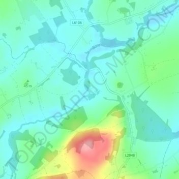
Wilton Castle topographic map
Interactive map
Click on the map to display elevation.
About this map
Name: Wilton Castle topographic map, elevation, terrain.
Average elevation: 41 m
Minimum elevation: 13 m
Maximum elevation: 127 m
Other topographic maps
Click on a map to view its topography, its elevation and its terrain.
Mangerton
Mangerton Mountain's height and topographic prominence, qualifies it to meet the British Isles Marilyn classification, as well as the Arderin, Simm and Hewitt classifications. Mangerton Mountain ranks as the 10th-highest mountain in Ireland on the MountainViews Online Database, 100 Highest Irish Mountains,…
Average elevation: 657 m
Newcastle West
Ireland > County Limerick > The Municipal District of Newcastle West
Average elevation: 58 m
Dundalk
The main part of the census town lies at sea level. Dún Dealgan Motte at Castletown is the highest point in the urban area at an elevation of 60 m (200 ft). The municipal district includes the Cooley Mountains, with Slieve Foy the highest of the peaks at an elevation of 589 m (1,932 ft).
Average elevation: 13 m
Blanchardstown
Blanchardstown was a predominantly rural area, with a small village, in western County Dublin, alongside the neighbouring district of Castleknock. Both areas shared a common history until well into the 19th century, when their development diverged. In A Topographical Dictionary of Ireland, published in 1837,…
Average elevation: 61 m
County Wicklow
The county experiences a narrow annual temperature range. Typical daytime highs range from 17–22 °C (63–72 °F) throughout the county in July and August, with overnight lows in the 11–14 °C (52–57 °F) range, although temperatures in the mountains can be 5–10 °C (41–50 °F) lower. Mean January…
Average elevation: 166 m
County Kerry
Bounded by the Atlantic Ocean, Kerry is Ireland's most westerly county. Its rugged coastline stretches for 886 kilometres (551 miles) and is characterised by bays, sea cliffs, beaches and many small offshore islands, of which the Blaskets and the Skelligs are the most notable. The county's peninsulas have a…
Average elevation: 123 m
Kilkenny
Kilkenny is situated in the Nore Valley on both banks of the River Nore, at the centre of County Kilkenny in the province of Leinster in the south-east of Ireland. It is 117 kilometres (73 mi) away the capital Dublin and 48 kilometres (30 mi) north from the nearest city Waterford. Wexford is 80 kilometres (50…
Average elevation: 62 m
Limerick
Limerick's climate is classified as temperate oceanic (Köppen Cfb). Met Éireann maintains a climatological weather station at Shannon Airport, 20 kilometres west of the city in County Clare. Shannon Airport records an average of 977 millimetres of precipitation annually, most of which is rain. Limerick has a…
Average elevation: 45 m
Gooseberry Hill
Ireland > County Limerick > The Municipal District of Cappamore — Kilmallock
Average elevation: 217 m
Castleknock
As the word Castle did not come into use in Ireland until Norman times we know that Castleknock is a name of comparatively recent origin. Documents from the 12th and 13th centuries refer to the place as Castrum Cnoc, simply Cnoc and also Chastel-cnoc or Castel-Cnoc.[8] So it seems that the name Castleknock is…
Average elevation: 55 m
Wellfield
Ireland > County Limerick > The Municipal District of Cappamore — Kilmallock
Average elevation: 80 m
Swords
Ireland > County Dublin > Swords
At the northern end of the street stands Swords Castle, 200m northeast of the ecclesiastical site, which was built in the early 13th century. A short distance north of the castle is the elevation known as Spittal Hill, where a hospital once stood.
Average elevation: 28 m