
Make a donation
Aceh topographic map
Click on the map to display elevation.
Make a donation
About this map
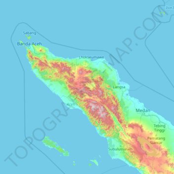
Name: Aceh topographic map, elevation, terrain.
Location: Aceh, Indonesia (1.76855 94.42530 6.96855 99.62530)
Average elevation: 176 m
Minimum elevation: -3 m
Maximum elevation: 3,314 m
Make a donation
Other topographic maps
Click on a map to view its topography, its elevation and its terrain.
Make a donation
Make a donation
Sulawesi
The lowland forests on the island have mostly been removed. Because of the relative geological youth of the island and its dramatic and sharp topography, the lowland areas are naturally limited in their extent. The past decade has seen dramatic conversion of this rare and endangered habitat. The island also…
Average elevation: 145 m
Sukabumi
At an altitude of approximately 584 m (1,916 ft), the city is a minor hill station resort, with a cooler climate than the surrounding lowlands. The area around Sukabumi is also a popular destination for whitewater rafting. Tea and Rubber production is a major industry in the area. The suburban area surrounding…
Average elevation: 570 m
Tasikmalaya
The city is located in the mountainous Priangan region of Java at an elevation of 351 metres (1,151 feet).
Average elevation: 367 m
Make a donation
Make a donation
Ciliwung
Mean rainfall reaches 3,125 mm, with a mean annual discharge of 16 m3/s as measured at Ciliwung Ratujaya observation station (231 km2). With such topographical, geological, and hydrological features, the Ciliwung River is often overflowing and inundating parts of Jakarta. The population along the Ciliwung…
Average elevation: 181 m
Make a donation
Pulau Bali
Bali's central mountains include several peaks over 2,000 metres (6,600 feet) in elevation and active volcanoes such as Mount Batur. The highest is Mount Agung (3,031 m, 9,944 ft), known as the "mother mountain", which is an active volcano rated as one of the world's most likely sites for a massive eruption…
Average elevation: 122 m
Make a donation
Pulau Enggano
Indonesia > Bengkulu > Bengkulu Utara
Enggano is about 35 kilometres (22 miles) long from east to west and about 16 kilometres (9.9 miles) wide from north to south. Its area is 400.6 square kilometres (154.7 square miles) including four small offshore islands around its coast - Pulau Merbau, Pulau Dua and tiny Pulau Banggai off Enggano's east…
Average elevation: 19 m
Make a donation
Make a donation
Make a donation
Make a donation
Make a donation
Penida Island
Indonesia > Bali > Klungkung Regency > Batukandik
Nusa Penida (Balinese: ᬦᬸᬲᬧᭂᬦᬶᬤ, romanized: Nusa Penida, lit. 'Penida Island') is an island located near the southeastern Indonesian island of Bali and a district of Klungkung Regency that includes the neighbouring small island of Nusa Lembongan and twelve even smaller islands. The Badung…
Average elevation: 104 m
Make a donation
Pulau Biak
Biak covers an area of 2,455 km2 (948 sq mi) The island is 72 km (45 mi) long and 37 km (23 mi) wide at its widest point. The highest point is approximately 740 meters elevation, located in the northwest of the island.
Average elevation: 49 m
Make a donation
Make a donation
Make a donation
Make a donation
Kedaung Kali Angke
Indonesia > Jakarta Special Capital Region > Kedaung Kali Angke
Average elevation: 4 m
Make a donation
Make a donation
Make a donation
Sanggau
Sanggau Regency borders Sintang and Sekadau Regencies in the east, Malaysia in the north, Ketapang Regency in the south, and Landak Regency in the west. Sanggau Regency is located in the interior of Borneo, and is divided by the Kapuas River, which is one of the longest rivers in Indonesia. Its topography is…
Average elevation: 106 m
Make a donation