
Aceh topographic map
Interactive map
Click on the map to display elevation.
About this map
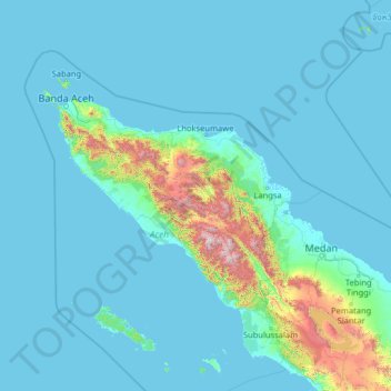
Name: Aceh topographic map, elevation, terrain.
Location: Aceh, Indonesia (1.76855 94.42530 6.96855 99.62530)
Average elevation: 176 m
Minimum elevation: -3 m
Maximum elevation: 3,314 m
Other topographic maps
Click on a map to view its topography, its elevation and its terrain.
Semarang
Semarang is located on the northern coast of Java. The city of Semarang is one of the most important cities located on the north coast of Java and is the main hub connecting Jakarta and Surabaya, and cities in the southern interior of Java Surakarta and Yogyakarta. Semarang City has a height ranging from 2 m…
Average elevation: 110 m
Borneo
Before sea levels rose at the end of the last ice age, Borneo was part of the mainland of Asia, forming, with Java and Sumatra, the upland regions of a peninsula that extended east from present day Indochina. The South China Sea and Gulf of Thailand now submerge the former low-lying areas of the peninsula.…
Average elevation: 141 m
Sulawesi
The lowland forests on the island have mostly been removed. Because of the relative geological youth of the island and its dramatic and sharp topography, the lowland areas are naturally limited in their extent. The past decade has seen dramatic conversion of this rare and endangered habitat. The island also…
Average elevation: 145 m
Jagakarsa
Indonesia > Special Capital Region of Jakarta
As one of the southernmost districts of Jakarta, Jagakarsa has a relatively higher elevation (average 52-meter above sea level) and a cooler climate than the rest of Jakarta (average 25–27-degree Celsius). Jagakarsa has been allotted for water reservoir use, resulting in low footprint for buildings in…
Average elevation: 54 m
Sukabumi
At an altitude of approximately 584 m (1,916 ft), the city is a minor hill station resort, with a cooler climate than the surrounding lowlands. The area around Sukabumi is also a popular destination for whitewater rafting. Tea and Rubber production is a major industry in the area. The suburban area surrounding…
Average elevation: 570 m
Tasikmalaya
The city is located in the mountainous Priangan region of Java at an elevation of 351 metres (1,151 feet).
Average elevation: 367 m
Ciliwung
Mean rainfall reaches 3,125 mm, with a mean annual discharge of 16 m3/s as measured at Ciliwung Ratujaya observation station (231 km2). With such topographical, geological, and hydrological features, the Ciliwung River is often overflowing and inundating parts of Jakarta. The population along the Ciliwung…
Average elevation: 181 m
Pulau Enggano
Indonesia > Bengkulu > Bengkulu Utara
Enggano is about 35 kilometres (22 miles) long from east to west and about 16 kilometres (9.9 miles) wide from north to south. Its area is 400.6 square kilometres (154.7 square miles) including four small offshore islands around its coast - Pulau Merbau, Pulau Dua and tiny Pulau Banggai off Enggano's east…
Average elevation: 19 m
West Papua
West Papua is located between 0–4 degrees South Latitude and 124–132 degrees East Longitude, just below the equator with an altitude of 0–100 m (0–328 ft) above sea level. The area of West Papua before the creation of Southwest Papua Province was 99,398.26 km2 (38,377.88 sq mi), and is currently about…
Average elevation: 95 m
East Java
East Java has a tropical monsoon and savanna climate at lower elevation and subtropical at higher elevation. Compared with the western part of Java Island, East Java in general has less rainfall. Average rainfall is 1,900 mm per year, with a rainy season during the 100 days. The average temperature ranges…
Average elevation: 62 m
West Nusa Tenggara
Selong (the capital of East Lombok Regency) is a city that has the highest altitude, which is 148 m above sea level, while the lowest Raba at 13 m above sea level. Of the seven mountains on the island of Lombok, Mount Rinjani is the highest mountain with an altitude of 3,775 m, while Mount Tambora on Sumbawa…
Average elevation: 45 m
West Kalimantan
Influenced by the vast lowlands, the heights of the mountains are relatively low as well as non-volcanically active. The highest mountain is Mount Baturaya in Serawai District of Sintang Regency which has an altitude of 2,278 metres above sea level, far lower than Mount Semeru (East Java, 3,676 metres) or…
Average elevation: 92 m
South Sumatra
On the east coast the land consists of swamps and brackets which are affected by tides. Its vegetation is in the form of palmate plants and mangrove. A little more western is a vast lowland. Far to the west near the border of Bengkulu and Jambi lies the Bukit Barisan mountains, which divides South Sumatra and…
Average elevation: 123 m
Java
Java is an island with a large amount of biodiversity. The natural environment of Java is tropical rainforest, with ecosystems ranging from coastal mangrove forest on the north coast, rocky coastal cliffs on the southern coast, and low-lying tropical forest to high altitude rainforest on the slopes of…
Average elevation: 39 m
Kota Bekasi
The City of Bekasi is a part of the Bekasi river basin, located in the downstream area of the basin with slopes ranging from 0 to 2% and elevations between 11 meters to 81 meters above sea level. The city of Bekasi is part of the Bekasi river basin and is located in the downstream area of the basin, with a…
Average elevation: 32 m
Pulau Bali
Bali's central mountains include several peaks over 2,000 metres (6,600 feet) in elevation and active volcanoes such as Mount Batur. The highest is Mount Agung (3,031 m, 9,944 ft), known as the "mother mountain", which is an active volcano rated as one of the world's most likely sites for a massive eruption…
Average elevation: 122 m
Bandung City
Bandung (Sundanese: ᮊᮧᮒ ᮘᮔ᮪ᮓᮥᮀ, romanized: Kota Bandung كَوتا باندوڠ, Sundanese pronunciation: [ˈbandʊŋ]; /ˈbɑːndʊŋ/) is the capital city of the Indonesian province of West Java. Greater Bandung (Bandung Basin Metropolitan Area / BBMA) is the country's second-largest and…
Average elevation: 830 m
Penida Island
Indonesia > Bali > Klungkung Regency > Batukandik
Nusa Penida (Balinese: ᬦᬸᬲᬧᭂᬦᬶᬤ, romanized: Nusa Penida, lit. 'Penida Island') is an island located near the southeastern Indonesian island of Bali and a district of Klungkung Regency that includes the neighbouring small island of Nusa Lembongan and twelve even smaller islands. The Badung…
Average elevation: 104 m
Pulau Biak
Biak covers an area of 2,455 km2 (948 sq mi) The island is 72 km (45 mi) long and 37 km (23 mi) wide at its widest point. The highest point is approximately 740 meters elevation, located in the northwest of the island.
Average elevation: 49 m