
West Nusa Tenggara topographic map
Interactive map
Click on the map to display elevation.
West Nusa Tenggara
Selong (the capital of East Lombok Regency) is a city that has the highest altitude, which is 148 m above sea level, while the lowest Raba at 13 m above sea level. Of the seven mountains on the island of Lombok, Mount Rinjani is the highest mountain with an altitude of 3,775 m, while Mount Tambora on Sumbawa is the highest mountain with an altitude of 2,851 m.
About this map
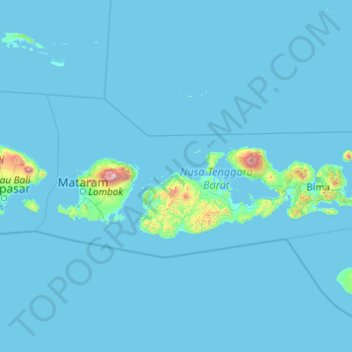
Name: West Nusa Tenggara topographic map, elevation, terrain.
Location: West Nusa Tenggara, Lesser Sunda Islands, Indonesia (-9.30984 115.57001 -7.51202 119.48874)
Average elevation: 45 m
Minimum elevation: 0 m
Maximum elevation: 3,330 m
Other topographic maps
Click on a map to view its topography, its elevation and its terrain.
Ciliwung
Mean rainfall reaches 3,125 mm, with a mean annual discharge of 16 m3/s as measured at Ciliwung Ratujaya observation station (231 km2). With such topographical, geological, and hydrological features, the Ciliwung River is often overflowing and inundating parts of Jakarta. The population along the Ciliwung…
Average elevation: 181 m
Sidoluhur
Indonesia > Special Region of Yogyakarta > Sleman Regency > Sidoagung
Average elevation: 120 m
Palangka Raya
Indonesia > Central Kalimantan > Palangka Raya
Palangka Raya borders Gunung Mas Regency to the north, Katingan Regency to the west, and Pulang Pisau Regency to the south and east. The area's soil consists mostly of peat and alluvium in its southern part and podzol on the northern part of the city. Overall, podzol soil dominates the city soil with 218,486…
Average elevation: 10 m
Angkinang Selatan
Indonesia > South Kalimantan > Hulu Sungai Selatan > Angkinang Selatan
Average elevation: 11 m