Geolocate

Falkirk topographic map

Interactive map

Click on the map to display elevation.

About this map

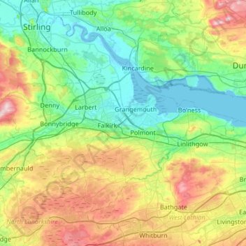
Name: Falkirk topographic map, elevation, terrain.

Location: Falkirk, Scotland, United Kingdom (55.89539 -4.03035 56.10863 -3.50120)

Average elevation: 105 m

Minimum elevation: -2 m

Maximum elevation: 361 m

Other topographic maps

Click on a map to view its topography, its elevation and its terrain.

Abington

United Kingdom > Scotland > South Lanarkshire

Average elevation: 309 m

Pitlochry

United Kingdom > Scotland > Perth and Kinross

Average elevation: 276 m

Wick

United Kingdom > Scotland > Highland

Average elevation: 20 m

Killin

United Kingdom > Scotland > Stirling

Average elevation: 174 m

Ayr

United Kingdom > Scotland > South Ayrshire

Average elevation: 18 m

Elderslie

United Kingdom > Scotland > Renfrewshire

Average elevation: 61 m

Monikie

United Kingdom > Scotland > Angus

Average elevation: 147 m

Inverie

United Kingdom > Scotland > Highland

Average elevation: 147 m

Portgordon

United Kingdom > Scotland > Moray

Average elevation: 22 m

Paisley

United Kingdom > Scotland > Renfrewshire

Average elevation: 33 m

Dunipace

United Kingdom > Scotland > Falkirk

Average elevation: 81 m

Ballater

United Kingdom > Scotland > Aberdeenshire

Ballater (/ˈbælətər/, Scottish Gaelic: Bealadair) is a village in Aberdeenshire, Scotland, on the River Dee, immediately east of the Cairngorm Mountains. Situated at an elevation of 213 metres (699 feet), Ballater is a centre for hikers and known for its spring water, once said to cure scrofula. It is home…

Average elevation: 360 m

Oldmeldrum

United Kingdom > Scotland > Aberdeenshire

Average elevation: 121 m

Glackmore

United Kingdom > Scotland > Highland > Inverness

Average elevation: 75 m

Daliburgh

United Kingdom > Scotland > Western Isles

Average elevation: 13 m

Greenock

United Kingdom > Scotland > Inverclyde

Average elevation: 80 m

Bothwell

United Kingdom > Scotland > South Lanarkshire

Average elevation: 65 m

Strathnairn

United Kingdom > Scotland > Highland > Daviot

Average elevation: 268 m

Livingston

United Kingdom > Scotland > West Lothian

Average elevation: 158 m

Lochore

United Kingdom > Scotland > Fife

Average elevation: 124 m

Dingwall

United Kingdom > Scotland > Highland

Average elevation: 94 m

Dunblane

United Kingdom > Scotland > Stirling

Average elevation: 117 m

Ramshead

United Kingdom > Scotland > East Renfrewshire > Hall

Average elevation: 149 m

Montrose

United Kingdom > Scotland > Angus

Montrose occupies a position on the North Bank of Montrose Basin at the mouth of the River South Esk on the East Coast of Scotland, 11 miles (18 km) NNE of Arbroath, 19 miles (31 km) SW of Stonehaven, and 7.2 miles (12 km) ESE of Brechin. The town lies 62.2 miles (100 km) NNE of Edinburgh, and 373.2 miles (601…

Average elevation: 22 m

Stonehaven

United Kingdom > Scotland > Aberdeenshire

Average elevation: 57 m

Ladybank

United Kingdom > Scotland > Fife

Average elevation: 44 m

Rothienorman

United Kingdom > Scotland > Aberdeenshire

Average elevation: 146 m

Teangue

United Kingdom > Scotland > Highland

Average elevation: 81 m

Gargunnock

United Kingdom > Scotland > Stirling

Average elevation: 94 m

Ratho

United Kingdom > Scotland > City of Edinburgh

Average elevation: 80 m

Stepps

United Kingdom > Scotland > North Lanarkshire

Average elevation: 73 m

Kilmore

United Kingdom > Scotland > Highland > Ferindonald

Average elevation: 61 m

Prestwick

United Kingdom > Scotland > South Ayrshire

Average elevation: 18 m

Rendall

United Kingdom > Scotland > Orkney Islands

Average elevation: 42 m

Johnstone

United Kingdom > Scotland > Renfrewshire

Average elevation: 65 m

Ayton

United Kingdom > Scotland > Scottish Borders

Average elevation: 75 m

Newton of Kinkell

United Kingdom > Scotland > Highland > Mulbuie

Average elevation: 112 m

Peebles

United Kingdom > Scotland > Scottish Borders

Average elevation: 275 m

Cumbernauld

United Kingdom > Scotland > North Lanarkshire

Cumbernauld's name probably comes from the Gaelic comar nan allt, meaning "meeting of the burns or streams". There are differing views as to the etymology of this. One theory is that from its high point in the Central Belt, its streams flow both west to the River Clyde and east to the Firth of Forth so…

Average elevation: 113 m

Newton

United Kingdom > Scotland > Dumfries and Galloway

Average elevation: 117 m

Killiedraught Bay

United Kingdom > Scotland > Eyemouth

Average elevation: 23 m

Kilmarnock

United Kingdom > Scotland > East Ayrshire

Average elevation: 56 m

Whitebridge

United Kingdom > Scotland > Highland

Average elevation: 223 m

Insh

United Kingdom > Scotland > Highland

Average elevation: 275 m

Durness

United Kingdom > Scotland > Highland

Average elevation: 28 m

Eyre

United Kingdom > Scotland > Highland

Average elevation: 72 m

Castletown

United Kingdom > Scotland > Highland

Average elevation: 25 m

Staffa

United Kingdom > Scotland > Argyll and Bute

Average elevation: 0 m

Ashens

United Kingdom > Scotland > Angus

Average elevation: 396 m

Crathie

United Kingdom > Scotland > Aberdeenshire

Average elevation: 359 m

Bo'ness

United Kingdom > Scotland > Falkirk

Average elevation: 29 m

Spin

United Kingdom > Scotland > Western Isles

Average elevation: 241 m

Keith

United Kingdom > Scotland > Moray

Average elevation: 180 m

West Belt

United Kingdom > Scotland > Aberdeen City

Average elevation: 72 m

Broadford

United Kingdom > Scotland > Highland

Average elevation: 34 m

Dounreay

United Kingdom > Scotland > Caithness

Average elevation: 36 m

East Mains

United Kingdom > Scotland > Aberdeenshire > Banchory

Average elevation: 99 m

Balbeggie

United Kingdom > Scotland > Perth and Kinross

Average elevation: 119 m

Reef

United Kingdom > Scotland > Western Isles

Average elevation: 18 m

Carmunnock

United Kingdom > Scotland > Glasgow City

Average elevation: 120 m

Glenmore

United Kingdom > Scotland > Highland

Average elevation: 414 m

Aviemore

United Kingdom > Scotland > Highland

Average elevation: 331 m

Moray Firth

United Kingdom > Scotland

Average elevation: 0 m

Armadale

United Kingdom > Scotland > West Lothian

Aside from the presence of the old castle, Armadale was little more than a rural farm community for most of its history, as part of a larger rural estate named Barbauchlaw (a corruption of 'Boar Baughlee'). However, this situation changed with the coming of the new turnpike road between Edinburgh and Glasgow…

Average elevation: 166 m

Cumnock

United Kingdom > Scotland > East Ayrshire

Average elevation: 187 m

Edinburgh

United Kingdom > Scotland > City of Edinburgh > Edinburgh

Some have called Edinburgh the Athens of the North for a variety of reasons. The earliest comparison between the two cities showed that they had a similar topography, with the Castle Rock of Edinburgh performing a similar role to the Athenian Acropolis. Both of them had flatter, fertile agricultural land…

Average elevation: 104 m

Renfrew

United Kingdom > Scotland > Renfrewshire

Average elevation: 16 m

Ardross

United Kingdom > Scotland > Highland

Average elevation: 223 m

Stow

United Kingdom > Scotland > Scottish Borders

Average elevation: 268 m

Ruddenleys

United Kingdom > Scotland > Scottish Borders

Average elevation: 319 m

St Fillans

United Kingdom > Scotland > Perth and Kinross

Average elevation: 292 m

Dalmore

United Kingdom > Scotland > Highland

Average elevation: 118 m

Arbroath

United Kingdom > Scotland > Angus

Average elevation: 24 m

North Ward

United Kingdom > Scotland > Shetland

Average elevation: 13 m

Glenelg

United Kingdom > Scotland > Highland

Average elevation: 78 m

Lossiemouth

United Kingdom > Scotland > Moray

Average elevation: 3 m

Pumpherston

United Kingdom > Scotland > West Lothian

Average elevation: 119 m

Braemar

United Kingdom > Scotland > Aberdeenshire

Braemar /breɪˈmɑːr/ (listen) is a village in Aberdeenshire, Scotland, around 58 miles (93 km) west of Aberdeen in the Highlands. It is the closest significantly-sized settlement to the upper course of the River Dee sitting at an elevation of 339 metres (1,112 ft).

Average elevation: 445 m

Dundonnell

United Kingdom > Scotland > Highland

Average elevation: 196 m

Bridge of Allan

United Kingdom > Scotland > Stirling

Average elevation: 80 m