
Kochi Prefecture topographic map
Interactive map
Click on the map to display elevation.
About this map
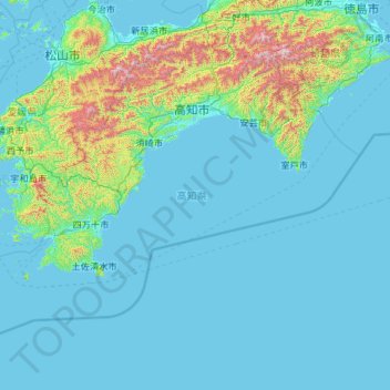
Name: Kochi Prefecture topographic map, elevation, terrain.
Location: Kochi Prefecture, Japan (32.38446 132.21266 33.88336 134.54238)
Average elevation: 155 m
Minimum elevation: -2 m
Maximum elevation: 1,883 m
Kōchi Prefecture comprises the southwestern part of the island of Shikoku, facing the Pacific Ocean. It is bordered by Ehime to the north-west and Tokushima to the north-east. It is the largest but least populous of Shikoku's four prefectures. Most of the province is mountainous, and in only a few areas such as around Kōchi and Nakamura is there a coastal plain. Kōchi is famous for its many rivers. Inamura-yama in Tosa-cho is the highest peak in Kōchi prefecture with an altitude of 1,506 meters above sea level.
Other topographic maps
Click on a map to view its topography, its elevation and its terrain.
Rusutsu
Rusutsu, Abuta County, Shiribeshi Subprefecture, Hokkaido Prefecture, Japan
Average elevation: 389 m
Ōsumi Islands
Ōsumi Islands, Kumage County, Kagoshima Prefecture, Japan
Average elevation: 29 m
Okinoerabujima
Japan > Oshima County > Wadomari
Okinoerabujima, Wadomari, Oshima County, Kagoshima Prefecture, Japan
Average elevation: 20 m
Shirakawa
Shirakawa, Ono County, Gifu Prefecture, Chubu Region, Japan
Average elevation: 1,207 m
Nakauonuma County
Nakauonuma County, Niigata Prefecture, Chubu Region, Japan
Average elevation: 605 m
Hakuba
Hakuba, Kita-Azumi County, Nagano Prefecture, Japan
Average elevation: 1,120 m
大島
Japan > Matsumae County > Matsumae
大島, Oshima, Matsumae, Matsumae County, Oshima Subprefecture, Hokkaido Prefecture, 049-1500, Japan
Average elevation: 157 m
Yusuhara
Yusuhara, Takaoka County, Kochi Prefecture, Japan
Average elevation: 662 m
Hashima Island
Hashima Island, Iwakuni, Yamaguchi Prefecture, Japan
Average elevation: 3 m
Naraha
Naraha, Futaba County, Fukushima Prefecture, Japan
Average elevation: 183 m
Obira
Obira, Rumoi County, Rumoi Subprefecture, Hokkaido Prefecture, Japan
Average elevation: 117 m
Jigoku-dani Valley
Japan > Kamikawa County > Higashikawa
Jigoku-dani Valley, Higashikawa, Kamikawa County, Kamikawa Subprefecture, Hokkaido Prefecture, Japan
Average elevation: 1,796 m
Mount Fuji
Japan > Sunto County > Oyama
Mount Fuji, Oyama, Sunto County, Shizuoka Prefecture, Chubu Region, Japan
Average elevation: 3,261 m
Ginan
Ginan, Hashima County, Gifu Prefecture, 501-6197, Japan
Average elevation: 13 m