Geolocate

Sri Lanka topographic map

Interactive map

Click on the map to display elevation.

Sri Lanka

Sri Lanka's topography is characterized by a diverse landscape that includes the Central Highlands, plains, and coastal regions. The Central Highlands, located in the south-central part of the island, form its rugged heartland, with the highest peak, Pidurutalagala, reaching 2,524 meters (8,281 feet). This area features a high plateau running north–south for approximately 65 kilometers (40 miles), with mountain ranges extending toward notable peaks like Adam's Peak (2,243 meters or 7,359 feet) and Namunukula (2,036 meters or 6,680 feet). Flanking these central ridges are lower plateaus such as the Hatton Plateau to the west and the Uva Basin to the east, characterized by rolling hills and deep valleys. Descending from the highlands, the terrain transitions into plains that range between 30 and 200 meters (98 to 656 feet) above sea level, with the southwestern plains displaying a dissected appearance due to gradual merging with the Central Highlands. The coastal belt encircles the island and features scenic sandy beaches, coastal lagoons, and, in certain areas like the northeast and southwest, rocky cliffs and bays formed by crystalline rock stratification.

About this map

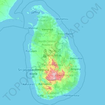
Name: Sri Lanka topographic map, elevation, terrain.

Location: Sri Lanka (5.71900 79.42199 10.03500 82.08101)

Average elevation: 50 m

Minimum elevation: -2 m

Maximum elevation: 2,379 m

Other topographic maps

Click on a map to view its topography, its elevation and its terrain.

Perth

Australia > Western Australia > City of Perth

Perth, the capital of Western Australia, is situated on the Swan Coastal Plain, a flat expanse of sandy soil nestled between the Indian Ocean to the west and the Darling Scarp to the east. The Darling Scarp, also known as the Darling Range, is a low escarpment that extends north–south, marking a distinct…

Average elevation: 26 m

Brisbane

Australia > Queensland > Brisbane

Average elevation: 45 m

Canberra

Australia

The area chosen for the capital had been inhabited by Indigenous Australians for up to 21,000 years, with the principal group being the Ngunnawal people. European settlement commenced in the first half of the 19th century, as evidenced by surviving landmarks such as St John's Anglican Church and Blundells…

Average elevation: 638 m

Adelaide

Australia > South Australia > Adelaide

Adelaide is north of the Fleurieu Peninsula, on the Adelaide Plains between the Gulf St Vincent and the low-lying Mount Lofty Ranges. The city stretches 20 km (12 mi) from the coast to the foothills, and 90 km (56 mi) from Gawler at its northern extent to Sellicks Beach in the south. According to the Regional…

Average elevation: 148 m

Gold Coast

Australia > Queensland > Gold Coast

Average elevation: 42 m

Bathurst

Australia > New South Wales

Average elevation: 760 m

Great Dividing Range

Australia

The Great Dividing Range, also known as the East Australian Cordillera or the Eastern Highlands, is a cordillera system in eastern Australia consisting of an expansive collection of mountain ranges, plateaus and rolling hills, that runs roughly parallel to the east coast of Australia and forms the…

Average elevation: 117 m

Gasmata

Papua New Guinea > West New Britain

Average elevation: 3 m

Townsville

Australia > Queensland

Average elevation: 30 m

Hervey Bay

Australia > Queensland

Average elevation: 6 m

Atherton

Australia > Queensland

Average elevation: 808 m

Darwin

Australia > City of Darwin

Average elevation: 8 m

Oslo

Norway > Oslo

Average elevation: 186 m

Blue Mountains

Australia > New South Wales

A sandstone plateau dominated by a landscape of endless eucalyptus forests, the Blue Mountains are located at the top of a 470-million-year-old quartzite. In the Permian period, a shallow sea covered the region, when rivers brought shales, siltstones and mudstones. Then during the Mesozoic period, rivers…

Average elevation: 566 m

Mount Dandenong

Australia > Victoria > Melbourne

Mount Dandenong has a cool oceanic climate (Cfb), with cool to mild summers and cold, damp winters. Daytime temperatures are usually 4−6 °C cooler than downtown Melbourne due to its elevation and distance from the urban heat island effect of Melbourne. It is significantly cloudier than Melbourne,…

Average elevation: 395 m

Poltava

Ukraine > Poltava Oblast > Poltava

Average elevation: 120 m

Xinjian Reservoir

China > Xinjiang > Qaraqash County

Average elevation: 1,339 m

Delhi

India > Delhi > Kotwali Tehsil

The topography of the medieval fort Purana Qila on the banks of the river Yamuna matches the literary description of the citadel Indraprastha in the Sanskrit epic Mahabharata; however, excavations in the area have revealed no signs of an ancient built environment. From the early 13th century until the mid-19th…

Average elevation: 216 m

Jindabyne

Australia > New South Wales > Jindabyne

Average elevation: 983 m

Busselton

Australia > Western Australia

Average elevation: 4 m

Maleny

Australia > Queensland > Maleny

Average elevation: 364 m

Grafton

Australia > New South Wales

Average elevation: 36 m

Mackay

Australia > Queensland

Average elevation: 13 m

Albany

Australia > Western Australia

Average elevation: 30 m

Bucharest

Romania > Bucharest > Bucharest

Average elevation: 82 m

Albury

Australia > New South Wales

Average elevation: 246 m

Geelong

Australia > Victoria

Average elevation: 42 m

Ballarat

Australia > Victoria

Ballarat has a moderate oceanic climate (Köppen climate classification Cfb) with four distinct seasons. Its elevation, ranging between 400 and 630 metres (1,310 and 2,070 feet) above sea level, causes its mean monthly temperatures to tend to be on average 3 to 5 °C (5 to 9 °F) below those of Melbourne,…

Average elevation: 470 m

Cairns

Australia > Queensland

South of Smithfield and inland from the Northern Beaches along the edge of the Barron River flood plain are the suburbs of Caravonica, Kamerunga, Freshwater, and Stratford. This area is sometimes referred to as Freshwater Valley, though it is actually the lower part of Redlynch Valley; further up the valley…

Average elevation: 176 m

Toowoomba

Australia > Queensland

The city occupies the edge of the range and the low ridges behind it. Two valleys run north from the southern boundary, each arising from springs either side of Middle Ridge near Spring Street at an altitude of around 680 m. These waterways, East Creek and West Creek, flow together just north of the CBD to…

Average elevation: 458 m

Wollongong

Australia > New South Wales > Wollongong

Average elevation: 115 m

Bundaberg

Australia > Queensland > Bundaberg Region

Average elevation: 18 m

Thrissur

India > Kerala > Thrissur

Thrissur is the headquarters of Thrissur district, in the center of the Indian state of Kerala. The city is 75 km north-east of Kochi, 133 km south-west of Coimbatore, 124 km south-east of Kozhikode and 151 km north of Changanacherry. The city is located in a hillock called Thekkinkadu Maidan which is the…

Average elevation: 36 m

Paup

Papua New Guinea > Sandaun

Average elevation: 7 m

Fountain Lakes

United States > Florida > Lee County

Average elevation: 5 m

Cobbold Gorge

Australia > Queensland

Average elevation: 329 m

Amanda

United States > Florida > Hillsborough County > Ruskin

Average elevation: 5 m

Sebakwe

Zimbabwe > Midlands Province > Kwekwe > Kwekwe

Average elevation: 1,179 m

Yarra Valley

Australia > Victoria > Melbourne

The Yarra Valley is the region surrounding the Yarra River in Victoria, Australia. The river originates approximately 240 km (150 mi) east of the Melbourne central business district and flows towards it and out into Port Phillip Bay. The name Yarra Valley is used in reference to the upper regions surrounding…

Average elevation: 305 m

Melbourne

Australia > Victoria

Melbourne is also prone to isolated convective showers forming when a cold pool crosses the state, especially if there is considerable daytime heating. These showers are often heavy and can include hail, squalls, and significant drops in temperature, but they often pass through very quickly with a rapid…

Average elevation: 49 m

Raleigh

United States of America > North Carolina > Raleigh

Raleigh is located in the northeast central region of North Carolina, where the Piedmont and Atlantic Coastal Plain regions meet. This area is known as the "fall line" because it marks the elevation inland at which waterfalls begin to appear in creeks and rivers. As a result, most of Raleigh features gently…

Average elevation: 103 m

Tamworth

Australia > New South Wales

Average elevation: 489 m

Cessnock

Australia > New South Wales

Average elevation: 142 m

Spring Hill

USA > Florida > Spring Hill

Average elevation: 35 m

Mount Lofty

Australia > South Australia

Average elevation: 554 m

Snowy Mountains

Australia > New South Wales

Average elevation: 2,011 m

Dubbo

Australia > New South Wales > Dubbo

Average elevation: 307 m

Cooma

Australia > New South Wales > Cooma

Average elevation: 860 m

Launceston

Australia > Tasmania > Launceston

Launceston is at 41°26′31″S 147°8′42″E / 41.44194°S 147.14500°E / -41.44194; 147.14500 in the Tamar Valley, Northern Tasmania. The valley was formed by volcanic and glacial forces over 10 million years ago. The city is about 45 kilometres (28 mi) south of the Bass Strait, with its closest…

Average elevation: 218 m

Beechworth

Australia > Victoria > Beechworth

Average elevation: 533 m

Bendigo

Australia > Victoria

Average elevation: 223 m

Queanbeyan

Australia > New South Wales

Average elevation: 716 m

Rockhampton

Australia > Queensland

Average elevation: 48 m

Sandy Hook

Australia > New South Wales

Average elevation: 575 m

Pakala

India > Andhra Pradesh > Pakala

Pakala consists of 180 villages and 28 panchayats. Nagamma Agraharam is the smallest village and Pakala is the biggest village. It is in the 371 m elevation (altitude).

Average elevation: 384 m

Zekeriyaköy

Turkey > Yapraklı

Average elevation: 1,232 m

Sydney

Australia > New South Wales

Phillip had been given no instructions for urban development, but in July 1788 submitted a plan for the new town at Sydney Cove. It included a wide central avenue, a permanent Government House, law courts, hospital and other public buildings, but no provision for warehouses, shops, or other commercial…

Average elevation: 32 m

Maitland

Australia > New South Wales > Maitland

Average elevation: 16 m

Hunter Valley

Australia > New South Wales > Cessnock

Average elevation: 70 m

Sheikh Zayed

Egypt > Giza

Average elevation: 103 m

Ballina

Australia > New South Wales > Ballina

Average elevation: 4 m

Bunbury

Australia > Western Australia

Average elevation: 14 m

Sue City

Australia > New South Wales

Average elevation: 831 m

Bribie Island

Australia > Queensland

Average elevation: 44 m

Ocean Grove

Australia > Victoria > Ocean Grove

Average elevation: 16 m

Gosford

Australia > New South Wales

Average elevation: 75 m

Stanthorpe

Australia > Queensland > Stanthorpe

Owing to its elevation, Stanthorpe features a subtropical highland climate. At an altitude of 811 metres (2,661 ft), Stanthorpe holds the record for the lowest temperature recorded in Queensland at −10.6 °C (12.9 °F) on 23 June 1961. Sleet and light snowfalls are occasionally recorded, with the most…

Average elevation: 840 m

Ipswich

Australia > Queensland > Ipswich

Average elevation: 73 m

Mount Selwyn

Australia > Victoria

Average elevation: 1,175 m

Manali

India > Himachal Pradesh > Manali

Average elevation: 2,606 m

Mount Gravatt

Australia > Queensland

Average elevation: 70 m

Pizarro

United States > Washington > Adams County

Average elevation: 510 m

Lima

Peru > Lima

The suburban district of Cieneguilla, the district of Pachacámac and the district of Chosica provide important tourist attractions among locals. Due to its elevation (over 500 masl), the sun shines in Chosica during the winter, being very visited by the residents of Lima to escape the urban fog.

Average elevation: 202 m

Narone Creek

Australia > New South Wales > Wollombi

Average elevation: 176 m

Al Jubayl

Saudi Arabia > Eastern Province

Average elevation: 5 m

Outrim Park

Australia > New South Wales > Sydney > Blaxland

Average elevation: 209 m

Onekaka

New Zealand > Tasman

Average elevation: 73 m

Dairy Mountain

Australia > New South Wales

Average elevation: 743 m

Swakopmund

Namibia > Erongo Region

Average elevation: 50 m

Ly

Switzerland > Wallis > Martigny > Trient

Average elevation: 2,234 m

Ruxby

United States > Washington > Walla Walla County

Average elevation: 285 m

Berkeley River

Australia > Western Australia

Average elevation: 175 m

Zoom

India > Sikkim > Soreng

Average elevation: 864 m

Mount Kosciuszko

Australia > New South Wales

Mount Kosciuszko is the highest summit in mainland Australia. Until 1977 it was possible to drive from Charlotte Pass to within a few metres of the summit, but in 1977 the road was closed to public motor vehicle access due to environmental concerns. The road is open from Charlotte Pass for walkers and cyclists…

Average elevation: 2,035 m

Warwick

Australia > Queensland > Warwick

Warwick has a humid subtropical climate (Köppen Cfa) with hot summers and cool to cold winters. It is slightly cooler and less humid than the proximate southeast Queensland coast due to its inland, elevation location. Frost is present in winter. The climate bears similarities with Richmond, an inland suburb…

Average elevation: 517 m

Kempsey

Australia > New South Wales > Kempsey

Average elevation: 15 m

Marysville

Australia > Victoria > Marysville

Average elevation: 491 m

Kinglake

Australia > Victoria > Kinglake

Average elevation: 416 m

St Andrews

United Kingdom > Scotland > Fife

Average elevation: 38 m

Miranda Park

Australia > New South Wales > Sydney

Average elevation: 39 m

Yarra Ridge

Australia > Victoria > Melbourne

Average elevation: 211 m