
म्याग्दी topographic map
Interactive map
Click on the map to display elevation.
About this map
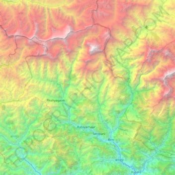
Name: म्याग्दी topographic map, elevation, terrain.
Location: म्याग्दी, Gandaki, 33208, Népal (28.29805 83.09990 28.79324 83.87029)
Average elevation: 3,357 m
Minimum elevation: 718 m
Maximum elevation: 8,142 m
Other topographic maps
Click on a map to view its topography, its elevation and its terrain.
Khumai Dada
Khumai Dada, Mardi Himal East ascent trail, Machhapuchchhre-01, Machhapuchchhre, कास्की, Gandaki, Népal
Average elevation: 2,813 m
Barhagaun Muktikhsetra
Barhagaun Muktikhsetra, मुस्ताङ, Gandaki, 33100, Népal
Average elevation: 4,743 m
Ārughāt Bāzār
Ārughāt Bāzār, Aarughat, गोरखा, Gandaki, Népal
Average elevation: 676 m
Ngadi Khola
Ngadi Khola, Marsyangdi, लमजुङ, Gandaki, 36000, Népal
Average elevation: 1,319 m
Dhampus Phedi
Dhampus Phedi, Machhapuchchhre, कास्की, Gandaki, Népal
Average elevation: 1,475 m
Mardi Himal
Mardi Himal, Machhapuchchhre, कास्की, Gandaki, Népal
Average elevation: 4,967 m
Tilicho Lake
Tilicho Lake, Neshyang-09, Neshyang, मनाङ, Gandaki, Népal
Average elevation: 5,062 m
Lo Manthang
Népal > Gandaki > Lo Manthang
Lo Manthang, Lomanthang, मुस्ताङ (Mustang), Gandaki, Népal
Average elevation: 3,958 m