
Mount Ngāuruhoe topographic map
Interactive map
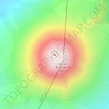
Click on the map to display elevation.
About this map
Name: Mount Ngāuruhoe topographic map, elevation, terrain.
Average elevation: 1,731 m
Minimum elevation: 1,337 m
Maximum elevation: 2,264 m
Other topographic maps
Click on a map to view its topography, its elevation and its terrain.
Napier
The topography puts Napier in danger from a tsunami, as the centre of the commercial city is near sea level – should the sea ever crest Marine Parade, the sea would run through to Ahuriri. Furthermore, by virtue of its pre-1931 existence, the bulk of Napier is susceptible to soil liquefaction, the risk…
Average elevation: 12 m
Palmerston North
New Zealand > Manawatu-Whanganui
Although the land Palmerston North is situated on is bounded by the lofty Ruahine and Tararua ranges in the east and south respectively, the city has a predominantly flat appearance. The occasional rise in elevation occurs further away from the river and is especially pronounced in the north and northeast, and…
Average elevation: 133 m
Lake Ōhau
New Zealand > Canterbury > Waitaki District
Wilding Pines (Pinus Cortorta, Pinus sylvestris) are problematic on the foreshore of Lake Ōhau. Pinus contorta grow “probably five to 10 times faster” in the Mackenzie Country (and Lake Ōhau) than in their native North America. They can establish themselves at altitudes of up to 2000 metres. Where they…
Average elevation: 904 m
Auckland
The Auckland Volcanic Field has contributed greatly to the growth and prosperity of the Auckland Region since the area was settled by humans. Initially, the maunga (scoria cones) were occupied and established as pā (fortified settlements) by Māori due to the strategic advantage their elevation provided in…
Average elevation: 30 m
Franz Josef Glacier
New Zealand > West Coast > Westland District
The névé or snowfield at the head of Franz Josef Glacier is over 2,500 metres (8,200 ft) above sea level and 20 square kilometres (7.7 sq mi) in area. This wide névé, which is over 300 metres (980 ft) deep, feeds large amounts of compacted snow into a steep and narrow valley which drops quickly to very low…
Average elevation: 1,709 m
Bay of Islands-Whangaroa Community
New Zealand > Northland > Far North District
Average elevation: 91 m
Lake Tekapo
New Zealand > Canterbury > Mackenzie District
Lake Tekapo (Māori: Takapō) is the second-largest of three roughly parallel lakes running north–south along the northern edge of the Mackenzie Basin in the South Island of New Zealand (the others are Lake Pukaki and Lake Ōhau). It covers an area of 83 square kilometres (32 sq mi) and is at an altitude of…
Average elevation: 1,025 m
Manawatū-Whanganui
The area includes a variety of landscape formations. Districts close to the Volcanic Plateau are higher and more rugged, often subject to harsh temperatures in winter. The Manawatū District has a much gentler topography, consisting mainly of the flat, tree-studded Manawatū Plains that run between the ranges…
Average elevation: 306 m
Milford Sound
New Zealand > Southland > Southland District > Fiordland Community
Average elevation: 655 m
Manawatāwhi / Three Kings Island
With an area of 4.04 square kilometres (1.56 sq mi), Manawatāwhi / Great Island is by far the largest island of the group. A northeastern peninsula, with an area of about 1 km2, is almost cut off by a 200 m wide but more than 80 m high isthmus formed by North West Bay and South East Bay. The island reaches an…
Average elevation: 3 m
Tongariro National Park
New Zealand > Manawatu-Whanganui > Ruapehu District
Like the whole of New Zealand, Tongariro National Park is situated in a temperate zone. The prevailing westerly winds gather water over the Tasman Sea. As the volcanoes of Tongariro National Park are the first significant elevations that these winds encounter on the North Island, besides Mount Taranaki, rain…
Average elevation: 888 m
Hollyford River
New Zealand > Southland > Southland District > Fiordland Community
Average elevation: 14 m
Lake Alabaster
New Zealand > Southland > Southland District > Fiordland Community
Average elevation: 605 m
Kaikoura
The Hutton's shearwater (Puffinus huttoni) or Kaikōura tītī is an endangered seabird in the family Procellariidae. It is found in waters around Australia and New Zealand but it only breeds in the Seaward Kaikōura Range in New Zealand. It is the only seabird in the world that breeds in an alpine…
Average elevation: 530 m
Linwood-Central-Heathcote Community
New Zealand > Canterbury > Christchurch City
Average elevation: 55 m
Halswell-Hornby-Riccarton Community
New Zealand > Canterbury > Christchurch City
Average elevation: 49 m