Auckland topographic map
Interactive map
Click on the map to display elevation.
About this map
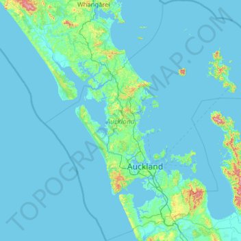
Name: Auckland topographic map, elevation, terrain.
Location: Auckland, New Zealand (-37.36447 173.89633 -35.69839 175.90322)
Average elevation: 30 m
Minimum elevation: -1 m
Maximum elevation: 836 m
The Auckland Volcanic Field has contributed greatly to the growth and prosperity of the Auckland Region since the area was settled by humans. Initially, the maunga (scoria cones) were occupied and established as pā (fortified settlements) by Māori due to the strategic advantage their elevation provided in controlling resources and key portages between the Waitematā and Manukau harbours. The rich volcanic soils found in these areas also proved ideal for the cultivation of crops, such as kūmara. Following European arrival, many of the maunga were transformed into quarries to supply the growing city with aggregate and building materials, and as a result were severely damaged or entirely destroyed. A number of the smaller maar craters and tuff rings were also removed during earthworks. Most of the remaining volcanic centres are now preserved within recreational reserves administered by Auckland Council, the Department of Conservation, and the Tūpuna Maunga o Tāmaki Makaurau Authority.
Other topographic maps
Click on a map to view its topography, its elevation and its terrain.
Mount Howitt
New Zealand > West Coast > Westland District
Mount Howitt, Westland District, West Coast, New Zealand
Average elevation: 1,577 m
Waiuku
New Zealand > Auckland > Franklin
Waiuku, Franklin, Auckland, 2123, New Zealand
Average elevation: 32 m
Clydevale
New Zealand > Otago > Clutha District
Clydevale, Clutha District, Otago, 9247, New Zealand
Average elevation: 39 m
Ōakura
New Zealand > Northland > Whangarei District
Ōakura, Whangārei District, Northland, 0184, New Zealand
Average elevation: 26 m
Mount Lloyd
New Zealand > Canterbury > Mackenzie District
Mount Lloyd, Mackenzie District, Canterbury, New Zealand
Average elevation: 1,610 m
Ashburton District
Ashburton District, Canterbury, New Zealand
Average elevation: 661 m
Tōtara North
New Zealand > Northland > Far North District > Bay of Islands-Whangaroa Community
Tōtara North, Bay of Islands-Whangaroa Community, Far North District, Northland, 0479, New Zealand
Average elevation: 67 m
Rotorua
New Zealand > Bay of Plenty > Rotorua Lakes District
Rotorua, Rotorua Lakes District, Bay of Plenty, 3010, New Zealand
Average elevation: 435 m
Taipa
New Zealand > Northland > Far North District > Te Hiku Community
Taipa, Te Hiku Community, Far North District, Northland, New Zealand
Average elevation: 17 m
Katikati
New Zealand > Bay of Plenty > Western Bay of Plenty District
Katikati, Western Bay of Plenty District, Bay of Plenty, 3129, New Zealand
Average elevation: 52 m
Pākiri
New Zealand > Auckland > Rodney
Pākiri, Rodney, Auckland, 0972, New Zealand
Average elevation: 80 m
Waiouru
New Zealand > Manawatu-Whanganui > Ruapehu District
Waiouru, Ruapehu District, Manawatū-Whanganui, 4825, New Zealand
Average elevation: 817 m
Whakapapa Island
New Zealand > Manawatu-Whanganui > Ruapehu District
Whakapapa Island, Ruapehu District, Manawatū-Whanganui, New Zealand
Average elevation: 544 m
Wānaka
New Zealand > Otago > Queenstown-Lakes District
Wānaka, Queenstown-Lakes District, Otago, 9305, New Zealand
Average elevation: 381 m
Karitane Point
New Zealand > Otago > Dunedin City
Karitane Point, Dunedin City, Otago, 9510, New Zealand
Average elevation: 1 m
Hokitika
New Zealand > West Coast > Westland District
Hokitika, Westland District, West Coast, 7810, New Zealand
Average elevation: 14 m
Milton
New Zealand > Otago > Clutha District
Milton, Clutha District, Otago, 9220, New Zealand
Average elevation: 55 m
Pongakawa
New Zealand > Bay of Plenty > Western Bay of Plenty District
Pongakawa, Western Bay of Plenty District, Bay of Plenty, 3186, New Zealand
Average elevation: 18 m
Kaituna River
New Zealand > Tasman > Tasman District
Kaituna River, Tasman District, Tasman, New Zealand
Average elevation: 263 m
Okere Falls
New Zealand > Bay of Plenty > Rotorua Lakes District
Okere Falls, Rotorua Lakes District, Bay of Plenty, New Zealand
Average elevation: 318 m
Franz Josef Glacier
New Zealand > West Coast > Westland District
Franz Josef Glacier, Westland District, West Coast, New Zealand
Average elevation: 1,709 m
Tamatea / Dusky Sound
New Zealand > Southland > Southland District
Tamatea / Dusky Sound, Southland District, Southland, New Zealand
Average elevation: 378 m
Oamaru
New Zealand > Otago > Waitaki District
Oamaru, Waitaki District, Otago, 9444, New Zealand
Average elevation: 34 m
Puketeraki
New Zealand > Canterbury > Selwyn District
Puketeraki, Selwyn District, Canterbury, New Zealand
Average elevation: 1,369 m
Methven
New Zealand > Canterbury > Ashburton District
Methven, Ashburton District, Canterbury, 7730, New Zealand
Average elevation: 322 m
Otaua
New Zealand > Waikato > Waikato District
Otaua, Waikato District, Waikato, 2682, New Zealand
Average elevation: 9 m
Forest Range
New Zealand > Southland > Southland District > Waihopai Toetoe Community
Forest Range, Waihopai Toetoe Community, Southland District, Southland, New Zealand
Average elevation: 373 m
Foxton
New Zealand > Manawatu-Whanganui > Horowhenua District
Foxton, Horowhenua District, Manawatū-Whanganui, 4814, New Zealand
Average elevation: 10 m
Matamata
New Zealand > Waikato > Matamata Piako District
Matamata, Matamata Piako District, Waikato, 3400, New Zealand
Average elevation: 67 m
Hydra Island
New Zealand > Canterbury > Selwyn District
Hydra Island, Selwyn District, Canterbury, New Zealand
Average elevation: 474 m
Bainesse
New Zealand > Manawatu-Whanganui > Manawatū District
Bainesse, Manawatū District, Manawatū-Whanganui, 4477, New Zealand
Average elevation: 27 m
South Island
New Zealand > Auckland > Waiheke
South Island, Waiheke, Auckland, New Zealand
Average elevation: 4 m
Tangimoana
New Zealand > Manawatu-Whanganui > Manawatū District
Tangimoana, Manawatū District, Manawatū-Whanganui, 4822, New Zealand
Average elevation: 5 m
Rangiotu
New Zealand > Manawatu-Whanganui > Manawatū District
Rangiotu, Manawatū District, Manawatū-Whanganui, New Zealand
Average elevation: 13 m
Glenorchy
New Zealand > Otago > Queenstown-Lakes District
Glenorchy, Queenstown-Lakes District, Otago, 9372, New Zealand
Average elevation: 384 m
Nokomai River
New Zealand > Southland > Southland District
Nokomai River, Southland District, Southland, New Zealand
Average elevation: 390 m
Mount Nathan
New Zealand > Canterbury > Mackenzie District
Mount Nathan, Mackenzie District, Canterbury, New Zealand
Average elevation: 2,344 m
Mangawhai
New Zealand > Northland > Kaipara District
Mangawhai, Kaipara District, Northland, 0505, New Zealand
Average elevation: 29 m
Owaka
New Zealand > Otago > Clutha District
Owaka, Clutha District, Otago, 9535, New Zealand
Average elevation: 27 m
Pearce
New Zealand > Canterbury > Christchurch City > Banks Peninsula Community
Pearce, Banks Peninsula Community, Christchurch City, Canterbury, 7581, New Zealand
Average elevation: 485 m
Sherenden
New Zealand > Hawke's Bay > Hastings District
Sherenden, Hastings District, Hawke's Bay, New Zealand
Average elevation: 258 m
Lofty
New Zealand > Wellington > Wellington City > Wellington
Lofty, Wellington, Wellington City, Wellington, 6012, New Zealand
Average elevation: 188 m
Mosgiel
New Zealand > Otago > Dunedin City
Mosgiel, Dunedin City, Otago, 9024, New Zealand
Average elevation: 55 m
Bay of Islands-Whangaroa Community
New Zealand > Northland > Far North District
Bay of Islands-Whangaroa Community, Far North District, Northland, New Zealand
Average elevation: 91 m