
Kalinga topographic map
Click on the map to display elevation.
Kalinga
Large swaths of the province's lowlands are open grassland suitable for pasture, while the highlands have extensive areas of tropical rainforest. In higher elevations to the west, particularly in the mountains of Balbalan, lie some of the most intact pine forests of Luzon island. Rizal and Tabuk with their flatlands are the biggest rice producers. Next in rice production are the mountainous area, and of note are the rice terraces of Balbalan, Lubuagan, Pasil, Pinukpuk, Tinglayan, and Tanudan.
About this map
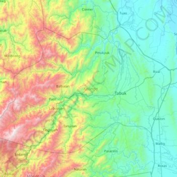
Name: Kalinga topographic map, elevation, terrain.
Location: Kalinga, Philippines (17.17124 120.91265 17.69011 121.65676)
Average elevation: 664 m
Minimum elevation: 10 m
Maximum elevation: 2,545 m
Other topographic maps
Click on a map to view its topography, its elevation and its terrain.
Surigao City
Philippines > Surigao Del Norte
Surigao City is marked by rolling hills that gently buffers its eastern and western boundaries. To the south-west towers the Kabangkaan Ridge which divides the city from the municipality of San Francisco (formerly Anao-aon). Kinabutan River (otherwise known as Surigao River) meanders Surigao valley before it…
Average elevation: 40 m
Caloocan
South Caloocan, where most commercial and industrial establishments are found, lies on generally flat and highly accessible land, with slopes ranging from 0-3%. The topography gradually changes into gently to moderately sloping to rolling along the North Luzon Expressway, with slopes ranging from 3-18%. The…
Average elevation: 19 m
Antipolo
Its higher elevation than that of Metro Manila affords it a scenic view of the metropolis, especially at night. Its locally grown mangoes and cashews are popular among tourists, as well as suman – a local delicacy made out of glutinous rice. The Hinulugang Taktak National Park, which was once a popular…
Average elevation: 125 m
Malolos
Malolos is relatively flat of about 0.81% to a gently sloping of 2.17%. The slope of the land descends towards west, southwest to southern direction. The highest land elevation is at about 6.0 meters above sea level while the lowest is only half a meter below sea level. A network of natural waterways and…
Average elevation: 6 m
Babuyan Islands
The following are the islands of Babuyan and their adjoining islets and rocks, along with land areas and highest elevation.
Average elevation: 0 m
San Luis
San Luis is generally rugged and mountainous. About 63% of its total land area is considered moderately high-to-high elevation highlands exceeding 500 metres (1,600 ft) above sea level. The rest of the area or 37% is less than 500 meters. The elevation ranges from 0 to 1,885 metres (6,184 ft) above sea level.
Average elevation: 68 m
San Mateo
The main source of the municipality's water supply are deep wells, pump wells (operated by Manila Water), open wells, springs and other ground water resources. Some of the elevated parts of the municipality are under watershed protected areas since the topography is characterized by rolling to mountainous…
Average elevation: 68 m
Pandi
Pandi is rich in many natural brooks coming from the mainland itself. In some remote areas the lands are still covered by bamboo trees that naturally thrive and multiplies. Some lands privately owned have mango plantations. In some areas that are privately owned are rock deposits being used for housing…
Average elevation: 27 m
Marawi
Marawi is located upon the shores of Lake Lanao. It is primarily inhabited by the Maranao people. The city is also called the "summer capital of the south" due to its higher elevation and cooler climate, a nickname it shares with Malaybalay.
Average elevation: 707 m