
Make a donation
Gear up for your next adventure:
As an Amazon Associate, this site earns from qualifying purchases at no extra cost to you.
Poland topographic map
Click on the map to display elevation.
Make a donation
Gear up for your next adventure:
As an Amazon Associate, this site earns from qualifying purchases at no extra cost to you.
Poland
Poland's topography is characterized by a diverse landscape that transitions from the Baltic Sea's sandy beaches in the north to mountainous regions in the south. The northern coastline features sand dunes and is indented by spits and lagoons, such as the Hel Peninsula and the Vistula Lagoon. Moving inland, the terrain is shaped by glacial activity, resulting in numerous lakes and gentle hills, particularly evident in the Masurian Lake District, which boasts over 2,000 lakes amidst dense forests. Central Poland is dominated by the expansive Polish Plain, a flat region crisscrossed by major rivers like the Vistula and the Oder, making it ideal for agriculture. Further south, the landscape becomes more varied with uplands and highlands, including the Lesser Poland Uplands, characterized by rolling hills and fertile valleys. The southernmost part of the country is marked by the Sudeten and Carpathian mountain ranges. The Carpathians encompass the Tatra Mountains, where Poland's highest peak, Mount Rysy, reaches 2,501 meters (8,205 feet). This diverse terrain supports a rich array of ecosystems and contributes to Poland's varied climate patterns.
Make a donation
Gear up for your next adventure:
As an Amazon Associate, this site earns from qualifying purchases at no extra cost to you.
About this map
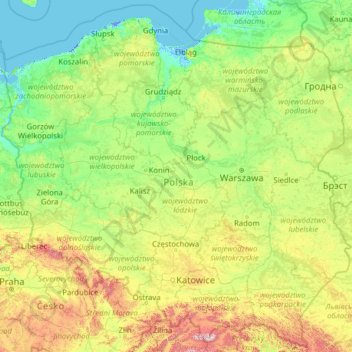
Name: Poland topographic map, elevation, terrain.
Location: Poland (49.00205 14.06964 55.03605 24.14578)
Average elevation: 194 m
Minimum elevation: -6 m
Maximum elevation: 2,237 m
Make a donation
Gear up for your next adventure:
As an Amazon Associate, this site earns from qualifying purchases at no extra cost to you.
Other topographic maps
Click on a map to view its topography, its elevation and its terrain.
Perth
Australia > Western Australia > City of Perth
Perth, the capital of Western Australia, is situated on the Swan Coastal Plain, a flat expanse of sandy soil nestled between the Indian Ocean to the west and the Darling Scarp to the east. The Darling Scarp, also known as the Darling Range, is a low escarpment that extends north–south, marking a distinct…
Average elevation: 26 m
Canberra
The area chosen for the capital had been inhabited by Indigenous Australians for up to 21,000 years, with the principal group being the Ngunnawal people. European settlement commenced in the first half of the 19th century, as evidenced by surviving landmarks such as St John's Anglican Church and Blundells…
Average elevation: 638 m
Adelaide
Australia > South Australia > Adelaide
Adelaide is north of the Fleurieu Peninsula, on the Adelaide Plains between the Gulf St Vincent and the low-lying Mount Lofty Ranges. The city stretches 20 km (12 mi) from the coast to the foothills, and 90 km (56 mi) from Gawler at its northern extent to Sellicks Beach in the south. According to the Regional…
Average elevation: 148 m
Make a donation
Gear up for your next adventure:
As an Amazon Associate, this site earns from qualifying purchases at no extra cost to you.
Toowoomba
The city occupies the edge of the range and the low ridges behind it. Two valleys run north from the southern boundary, each arising from springs either side of Middle Ridge near Spring Street at an altitude of around 680 m. These waterways, East Creek and West Creek, flow together just north of the CBD to…
Average elevation: 458 m
Sydney
Phillip had been given no instructions for urban development, but in July 1788 submitted a plan for the new town at Sydney Cove. It included a wide central avenue, a permanent Government House, law courts, hospital and other public buildings, but no provision for warehouses, shops, or other commercial…
Average elevation: 32 m
Make a donation
Gear up for your next adventure:
As an Amazon Associate, this site earns from qualifying purchases at no extra cost to you.
Ballarat
Ballarat has a moderate oceanic climate (Köppen climate classification Cfb) with four distinct seasons. Its elevation, ranging between 400 and 630 metres (1,310 and 2,070 feet) above sea level, causes its mean monthly temperatures to tend to be on average 3 to 5 °C (5 to 9 °F) below those of Melbourne,…
Average elevation: 470 m
Great Dividing Range
The Great Dividing Range, also known as the East Australian Cordillera or the Eastern Highlands, is a cordillera system in eastern Australia consisting of an expansive collection of mountain ranges, plateaus and rolling hills, that runs roughly parallel to the east coast of Australia and forms the…
Average elevation: 117 m
Make a donation
Gear up for your next adventure:
As an Amazon Associate, this site earns from qualifying purchases at no extra cost to you.
Make a donation
Gear up for your next adventure:
As an Amazon Associate, this site earns from qualifying purchases at no extra cost to you.
Launceston
Australia > Tasmania > Launceston
Launceston is at 41°26′31″S 147°8′42″E / 41.44194°S 147.14500°E / -41.44194; 147.14500 in the Tamar Valley, Northern Tasmania. The valley was formed by volcanic and glacial forces over 10 million years ago. The city is about 45 kilometres (28 mi) south of the Bass Strait, with its closest…
Average elevation: 218 m
Make a donation
Gear up for your next adventure:
As an Amazon Associate, this site earns from qualifying purchases at no extra cost to you.
Mount Kosciuszko
Mount Kosciuszko is the highest summit in mainland Australia. Until 1977 it was possible to drive from Charlotte Pass to within a few metres of the summit, but in 1977 the road was closed to public motor vehicle access due to environmental concerns. The road is open from Charlotte Pass for walkers and cyclists…
Average elevation: 2,035 m
Make a donation
Gear up for your next adventure:
As an Amazon Associate, this site earns from qualifying purchases at no extra cost to you.
Carcar
The land is generally level with less than 18% slope comprising 78.7% of the total land area. Areas with slopes ranging from 18 to 50% cover 19.3% of the total land area and those over 50% slope comprise approximately 1.9%. The highest recorded elevation is a little over 660 metres (2,170 ft) above sea level,…
Average elevation: 97 m
Make a donation
Gear up for your next adventure:
As an Amazon Associate, this site earns from qualifying purchases at no extra cost to you.
Airplane Basin Falls
Canada > British Columbia > Fraser Valley Regional District > Area E (Chilliwack River Valley)
Average elevation: 1,487 m
Australian Alps
The Australian Alps are a mountain range in southeast Australia. It comprises an interim Australian bioregion, and is the highest mountain range in Australia. The range straddles the borders of eastern Victoria, southeastern New South Wales, and the Australian Capital Territory. It contains Australia's only…
Average elevation: 2,037 m
Make a donation
Gear up for your next adventure:
As an Amazon Associate, this site earns from qualifying purchases at no extra cost to you.
Make a donation
Gear up for your next adventure:
As an Amazon Associate, this site earns from qualifying purchases at no extra cost to you.
Mount Banks
Mount Banks, otherwise known as Mount King George, is a mountain within the Explorers Range of the Blue Mountains Range that is a spur off the Great Dividing Range, is located within the Blue Mountains National Park, approximately 100 kilometres (62 mi) west of Sydney in New South Wales, Australia. Mount Banks…
Average elevation: 745 m
Make a donation
Gear up for your next adventure:
As an Amazon Associate, this site earns from qualifying purchases at no extra cost to you.
Makrinitsa
Greece > Thessaly > Regional Unit of Magnesia > Volos Municipality
Average elevation: 663 m
Make a donation
Gear up for your next adventure:
As an Amazon Associate, this site earns from qualifying purchases at no extra cost to you.
Keren
Keren (Tigrinya and Tigre: ከረን, Arabic: كرن, Italian: Cheren), historically known as Sanhit, is the second-largest city in Eritrea. It is situated around 91 kilometres (57 mi) northwest of Asmara at an elevation of 1,590 metres (5,220 ft) above sea-level. The city sprawls on a wide basin surrounded by…
Average elevation: 1,456 m
Melbourne
Melbourne is also prone to isolated convective showers forming when a cold pool crosses the state, especially if there is considerable daytime heating. These showers are often heavy and can include hail, squalls, and significant drops in temperature, but they often pass through very quickly with a rapid…
Average elevation: 49 m
Make a donation
Gear up for your next adventure:
As an Amazon Associate, this site earns from qualifying purchases at no extra cost to you.
Frankston
Australia > Victoria > Frankston
Olivers Hill is the most prominent elevation in Frankston which rises to 55 metres above sea level (180 feet) at its highest point in the suburb. Its origins date to approximately 415 to 360 million years ago. Its base is Mount Eliza Granite dating from the Devonian period, which was covered in lava tuffs in…
Average elevation: 36 m
Bahla Fort
Oman > Ad Dakhiliyah Governorate > Bahla Province
Preservation attempt in 1995 was found to be a renovation not a restoration because the aim of the remodeling was to make the fort look new. This renovation began without prior archaeological, topographic, architectural or technical surveys.
Average elevation: 575 m
Make a donation
Gear up for your next adventure:
As an Amazon Associate, this site earns from qualifying purchases at no extra cost to you.
Raleigh
United States of America > North Carolina > Raleigh
Raleigh is located in the northeast central region of North Carolina, where the Piedmont and Atlantic Coastal Plain regions meet. This area is known as the "fall line" because it marks the elevation inland at which waterfalls begin to appear in creeks and rivers. As a result, most of Raleigh features gently…
Average elevation: 103 m
Vadodara
India > Gujarat > Vadodara Rural Taluka
Vadodara is located at 22°18′N 73°11′E / 22.30°N 73.19°E / 22.30; 73.19 in western India at an elevation of 128 ft (39 m). It is the 10th-largest city in India with an area of 400 km2 (150 sq mi) and a population of 3.5 million, according to the 2010–11 census. The city sits on the banks of…
Average elevation: 36 m
Make a donation
Gear up for your next adventure:
As an Amazon Associate, this site earns from qualifying purchases at no extra cost to you.
Hopeland
United States > Pennsylvania > Lancaster County > Clay Township > Clay
Average elevation: 155 m
Make a donation
Gear up for your next adventure:
As an Amazon Associate, this site earns from qualifying purchases at no extra cost to you.
Little Saint James Island
United States > United States Virgin Islands > Saint Thomas - Saint John District
Average elevation: 1 m
Make a donation
Gear up for your next adventure:
As an Amazon Associate, this site earns from qualifying purchases at no extra cost to you.
Sunshine Coast
Australia > Queensland > Sunshine Coast Regional
The Sunshine Coast in Queensland, Australia, showcases a diverse topography that harmoniously blends coastal plains with rugged hinterlands. Along its eastern edge, the region features expansive sandy beaches and coastal dunes that transition smoothly into fertile lowlands. Inland, the terrain becomes more…
Average elevation: 109 m
Make a donation
Gear up for your next adventure:
As an Amazon Associate, this site earns from qualifying purchases at no extra cost to you.
Eldon B. Kieth Field
United States > Massachusetts > Plymouth County > Brockton
Average elevation: 40 m
Make a donation
Gear up for your next adventure:
As an Amazon Associate, this site earns from qualifying purchases at no extra cost to you.
Ponus
United States > Connecticut > Western Connecticut Planning Region > New Canaan
Average elevation: 77 m
Make a donation
Gear up for your next adventure:
As an Amazon Associate, this site earns from qualifying purchases at no extra cost to you.
Yarra Valley
Australia > Victoria > Melbourne
The Yarra Valley is the region surrounding the Yarra River in Victoria, Australia. The river originates approximately 240 km (150 mi) east of the Melbourne central business district and flows towards it and out into Port Phillip Bay. The name Yarra Valley is used in reference to the upper regions surrounding…
Average elevation: 305 m
Make a donation
Gear up for your next adventure:
As an Amazon Associate, this site earns from qualifying purchases at no extra cost to you.
Les Granges
France > Auvergne-Rhône-Alpes > Upper Savoy > Chamonix-Mont-Blanc > Les Bossons
Average elevation: 1,363 m
Make a donation
Gear up for your next adventure:
As an Amazon Associate, this site earns from qualifying purchases at no extra cost to you.
Make a donation
Gear up for your next adventure:
As an Amazon Associate, this site earns from qualifying purchases at no extra cost to you.
Make a donation
Gear up for your next adventure:
As an Amazon Associate, this site earns from qualifying purchases at no extra cost to you.
Cairns
South of Smithfield and inland from the Northern Beaches along the edge of the Barron River flood plain are the suburbs of Caravonica, Kamerunga, Freshwater, and Stratford. This area is sometimes referred to as Freshwater Valley, though it is actually the lower part of Redlynch Valley; further up the valley…
Average elevation: 176 m
Caloundra
Australia > Queensland > Sunshine Coast Regional
Caloundra, located on Queensland's Sunshine Coast, features a diverse coastal topography characterized by sandy beaches, rocky headlands, and nearby elevated terrains. The suburb of Kings Beach exemplifies this diversity, with its sandy shoreline to the south and southeast, and a rocky headland rising to about…
Average elevation: 5 m
Make a donation
Gear up for your next adventure:
As an Amazon Associate, this site earns from qualifying purchases at no extra cost to you.
Make a donation
Gear up for your next adventure:
As an Amazon Associate, this site earns from qualifying purchases at no extra cost to you.