
Çankırı topographic map
Interactive map
Click on the map to display elevation.
Çankırı
Çankırı has a dry summer continental climate (Köppen climate classification Dsa and Dsb) with humid continental climate (Dfa and Dfb) characteristics, since the wettest part of the year is spring and early summer. The province displays all four of these continental climate subtypes depending on location and elevation. The city is located in a transitional region of the province. Summers are usually hot and dry and winters are cold and snowy.
About this map
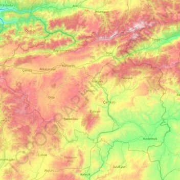
Name: Çankırı topographic map, elevation, terrain.
Location: Çankırı, Central Anatolia Region, Turkey (40.25480 32.56918 41.08917 34.16569)
Average elevation: 1,134 m
Minimum elevation: 304 m
Maximum elevation: 2,526 m
Other topographic maps
Click on a map to view its topography, its elevation and its terrain.
Gaziantep
The plan introduced several important changes to the city's transportation network. One of the most important was the addition of a rail line to connect Gaziantep to the national rail system. Up to now, Turkish railway construction had ignored Gaziantep (partly because of its mountainous surroundings); a…
Average elevation: 880 m
Eskisehir
Eskişehir has a cold semi-arid climate (BSk) under the Köppen climate classification, and a temperate continental climate (Dc) under the Trewartha climate classification. The city features cold, snowy winters and warm, dry summers. Rainfall occurs mostly during the spring and autumn. Due to Eskişehir's high…
Average elevation: 949 m
Ankara
Ankara has a hot-summer Mediterranean climate (Köppen Csa) which closely borders a hot summer Mediterranean continental climate (Köppen Dsa). Under the Trewartha climate classification, Ankara has a middle latitude steppe climate (BSk). Due to its elevation and inland location, Ankara has cold, somewhat…
Average elevation: 1,082 m
Denizli
Turkey > Aegean Region > Denizli > Merkezefendi
Denizli is an industrial city in the southwestern part of Turkey and the eastern end of the alluvial valley formed by the river Büyük Menderes, where the plain reaches an elevation of about three hundred and fifty metres (1,148 ft). Denizli is located in the country's Aegean Region.
Average elevation: 758 m
Karabük
Karabük is a town and the capital district of Karabük Province in the Black Sea region of Turkey. According to the 2009 census, population of the city is 108 167. The district covers an area of 760 km2 (293 sq mi), and the town lies at an elevation of 354 m (1,161 ft).
Average elevation: 864 m
Trabzon
Trabzon has a climate typical of the Black Sea region with plentiful precipitation. Under the Köppen climate classification, it has a humid subtropical climate (Köppen: Cfa). Summers are warm and humid, and the average maximum temperature is around 26.7 °C (80 °F) in August. Winters are cool and damp, and…
Average elevation: 241 m
Yozgat
Turkey > Yozgat Merkez > Yozgat
The town is located at an elevation of 4,380 ft (1,335 m), situated 105 mi (170 km) east of Ankara, near the head of a narrow valley through which the Ankara–Sivas road runs. Like much of the Anatolian Plateau, the lands around Yozgat have been deforested over thousands of years of human habitation. This…
Average elevation: 1,250 m