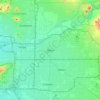
Minnesota topographic map
Click on the map to display elevation.
Minnesota
Minnesota’s topography is a predominantly glacial landscape of broad plains, rolling uplands, morainic ridges, lake basins, wetlands, and river-cut valleys, giving the state a generally gentle but regionally varied relief. Across much of central and northern Minnesota, repeated ice advances left deep drift deposits, outwash plains, till plains, drumlin fields, pitted terrain, and thousands of lake-filled depressions, creating the state’s characteristic lake-dotted surface. The northeast is the most rugged part of Minnesota, where the Superior Upland and Canadian Shield bedrock form rocky hills, ridges, and sharper relief above the Lake Superior basin; Eagle Mountain reaches about 2,301 feet (701 m), while the Lake Superior shoreline lies near 600 feet (183 m). To the west and northwest, the land opens into flatter glacial lake plains and prairie lowlands associated with the Red River basin, while southern and southwestern Minnesota are marked by smoother agricultural plains, subdued divides, and broad river valleys. In the southeast, the Driftless Area contrasts with the rest of the state through more deeply dissected valleys, bluffs, and exposed bedrock, giving Minnesota an overall physical character that shifts from low-relief glacial plains and wetlands to rocky northeastern highlands and steep-sided southeastern river country.
About this map
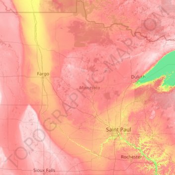
Name: Minnesota topographic map, elevation, terrain.
Location: Minnesota, United States (43.49943 -97.23926 49.38447 -89.48339)
Average elevation: 378 m
Minimum elevation: 176 m
Maximum elevation: 678 m
Other topographic maps
Click on a map to view its topography, its elevation and its terrain.

Little Saint James Island
United States > United States Virgin Islands > Saint Thomas - Saint John District
Average elevation: 1 m

Mendenhall Glacier
United States > Alaska > Juneau
The two small parking lots have access to several trails in the area. Photo Point Trail and the Steep Creek Trail are easy and accessible trails. Elevated boardwalks above Steep Creek provide salmon and bear viewing opportunities. Visitors can hike via the East Glacier Loop to an overlook within 1 mile (1,600…
Average elevation: 974 m
Monument Valley
United States > Arizona > Navajo County
The area is part of the Colorado Plateau. The elevation of the valley floor ranges from 5,000 to 6,000 feet (1,500 to 1,800 m) above sea level. The floor is largely siltstone of the Cutler Group, or sand derived from it, deposited by the meandering rivers that carved the valley. The valley's vivid red color…
Average elevation: 1,675 m
Atlantic Coastal Plain
United States > North Carolina > Cumberland County > Fayetteville
The province's average elevation is less than 900 meters above sea level and extends some 50 to 100 kilometers inland from the ocean. The coastal plain is normally wet, including many rivers, marsh, and swampland. It is composed primarily of sedimentary rock and unlithified sediments and is primarily used for…
Average elevation: 51 m
Short Hills
United States > New Jersey > Essex County > Millburn > Short Hills
Average elevation: 98 m
Colorado Springs
United States > Colorado > El Paso County
At 6,035 feet (1,839 m) the city stands over 1 mile (1.6 km) above sea level. Colorado Springs is near the base of Pikes Peak, which rises 14,115 feet (4,302.31 m) above sea level on the eastern edge of the Southern Rocky Mountains. The city is the largest city north of Mexico above 6000 feet in elevation.
Average elevation: 2,229 m
Jacksonville
United States > Florida > Duval County > Jacksonville
Just south of Jacksonville and north of Saint Augustine is the boundary of where the Floridian Peninsula ends and Continental North America begins; Jacksonville is north of that line. While still in the North American Coastal plain, the topography begins to take on slight Piedmont characteristics. Like the…
Average elevation: 9 m
Pere Marquette River
United States > Michigan > Mason County > Ludington > Buttersville
Average elevation: 180 m
Dallas
United States > Texas > Dallas County > Dallas
Dallas and its surrounding area are mostly flat. The city lies at elevations ranging from 450 to 550 feet (137 to 168 m) above sea level. The western edge of the Austin Chalk Formation, a limestone escarpment (also known as the "White Rock Escarpment"), rises 230 feet (70 m) and runs roughly north–south…
Average elevation: 158 m
Agua Dulce
United States > California > Agua Dulce
Agua Dulce (Spanish for "sweet water") is a census-designated place in Los Angeles County, California, United States. It lies at an elevation of 2,526 feet (770 m), northeast of Santa Clarita. The community had a population of 3,342 at the 2010 census and covers a geographic area of about 23 square miles (59…
Average elevation: 803 m
Grand Mere State Park
United States > Michigan > Berrien County > Stevensville
Average elevation: 185 m
Forest Lake
United States > Minnesota > Washington County > Forest Lake > Forest Lake
Average elevation: 277 m



Yosemite Valley
United States > California > Mariposa County > Yosemite Village
Average elevation: 2,016 m

Camp Kingsmont
United States > Massachusetts > Berkshire County > West Stockbridge
Average elevation: 421 m

Stony Creek
United States > Michigan > Washtenaw County > Augusta Charter Township
Average elevation: 228 m

Eureka
United States > California > Humboldt County > Eureka
The city marina is on one of three islands at a narrow point on the 13-mile-long (21 km) bay and increases in elevation slightly as it spreads north, south, and especially to the east. The city gently encroaches at least two miles (3.2 km) eastward into primarily Redwood and Douglas-fir second growth forests.…
Average elevation: 100 m
Mount Vernon
United States > Missouri > Lawrence County > Mount Vernon > Mount Vernon
Average elevation: 379 m

Evergreen
United States > Colorado > Jefferson County
Evergreen sits at an elevation of 7,220 feet (2,200 m) in the Rocky Mountains, 19 miles west of Denver, Colorado.
Average elevation: 2,301 m
Orange Grove Estates
United States > South Carolina > Charleston County > Charleston
Average elevation: 4 m

Mill Run
United States > Pennsylvania > Blair County > Altoona > Allegheny Furnace
Average elevation: 349 m
Yellowstone River
United States > Montana > Custer County
The mainstem of the Yellowstone River is more than 700 miles (1,100 km) long. At the headwaters, elevations exceed 12,800 feet (3,900 m) above sea level and descends to 1,850 feet (560 m) at the confluence with the Missouri River in far western North Dakota. The watershed spans 34,167 square miles (88,490…
Average elevation: 720 m
Salt Lake City
United States > Utah > Salt Lake County > Salt Lake City
Salt Lake City has an area of 110.4 square miles (286 km2) and an average elevation of 4,327 feet (1,319 m) above sea level. The lowest point within the boundaries of the city is 4,210 feet (1,280 m) near the Jordan River and the Great Salt Lake, and the highest is Grandview Peak, at 9,410 feet (2,868 m).
Average elevation: 1,625 m


East Litchfield
United States > Connecticut > Northwest Hills Planning Region > Litchfield
Average elevation: 239 m

Oakville
United States > Pennsylvania > Cumberland County > North Newton Township
Average elevation: 180 m

Wesley Chapel
United States > Florida > Pasco County
According to the United States Census Bureau, the CDP has a total area of 6.1 square miles (16 km2), of which 6.1 square miles (16 km2) is land and 0.04 square miles (0.10 km2) (0.49%) is water. The elevation is about 100 feet (30 m), combined with an inland location, creates more temperature variation in the…
Average elevation: 19 m