
Buhweju topographic map
Interactive map
Click on the map to display elevation.
About this map
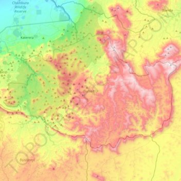
Name: Buhweju topographic map, elevation, terrain.
Location: Buhweju, Western Region, Uganda (-0.45505 30.09690 -0.18557 30.51874)
Average elevation: 1,495 m
Minimum elevation: 920 m
Maximum elevation: 2,168 m
Other topographic maps
Click on a map to view its topography, its elevation and its terrain.
Duka
Uganda > Bugisa sub-region > Mbale City
Duka, Mbale City, Bugisa sub-region, Eastern Region, Uganda
Average elevation: 1,132 m
Ddewe Bwebajja A
Uganda > Central Region > Entebbe City
Ddewe Bwebajja A, Entebbe City, Central Region, Uganda
Average elevation: 1,185 m
Education
Uganda > Bulambuli > Bugisa sub-region
Education, Bugisa sub-region, Bulambuli, Eastern Region, Uganda
Average elevation: 1,088 m
Rubaga
Uganda > Central Region > Kampala
Rubaga, Kampala, Central Region, Uganda
Average elevation: 1,187 m
Kitovu Nume
Uganda > Central Region > Masaka City
Kitovu Nume, Masaka City, Central Region, Uganda
Average elevation: 1,240 m
Kigoowa I
Uganda > Central Region > Kampala
Kigoowa I, Kampala, Central Region, Uganda
Average elevation: 1,194 m
Nakawa
Uganda > Central Region > Kampala
Nakawa, Kampala, Central Region, Uganda
Average elevation: 1,178 m
Ruhaama Central
Ruhaama Central, Ntungamo, Western Region, Uganda
Average elevation: 1,559 m
Kabazana B
Kabazana B, Kashojwa, Buganza, Isingiro, Western Region, Uganda
Average elevation: 1,274 m
Senior Quarters 'a'
Senior Quarters 'a', Tororo, Eastern Region, Uganda
Average elevation: 1,198 m