
Mount Palmer topographic map
Interactive map
Click on the map to display elevation.
About this map
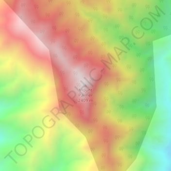
Name: Mount Palmer topographic map, elevation, terrain.
Location: Mount Palmer, Inyo County, California, United States (36.90656 -117.13317 36.90666 -117.13307)
Average elevation: 1,946 m
Minimum elevation: 1,443 m
Maximum elevation: 2,399 m
Other topographic maps
Click on a map to view its topography, its elevation and its terrain.
Seaside
United States > California > Monterey County
Seaside, formerly East Monterey, is a city in Monterey County, California, United States, with a population of 32,366 as of the 2020 census. It is located 2.25 miles (3.6 km) east-northeast of Monterey, at an elevation of 33 feet (10 m), and is the home of California State University, Monterey Bay (CSUMB), UC…
Average elevation: 69 m
Corcoran
United States > California > Kings County
Corcoran is a city in Kings County, California, United States. The population was 24,813 (2010 census), up from 14,458 (2000 census). Corcoran is located 17 miles (27 km) south-southeast of Hanford, at an elevation of 207 ft (63 m).
Average elevation: 62 m
Chatsworth Neighborhood Council District
United States > California > Los Angeles County > Los Angeles
Average elevation: 361 m
Sequoia National Forest
The Sequoia National Forest covers 1,193,315 acres (1,864.555 sq mi; 4,829.17 km2), and ranges in elevation from 1,000 feet (300 m) in the foothills of the Sierra Nevada to over 12,000 feet (3,700 m). Its giant sequoia (Sequoiadendron giganteum) groves are part of its 196,000 acres (790 km2) of old growth…
Average elevation: 1,326 m
Humboldt County
The coastal zone of the county experiences very wet, cool winters and dry, mild foggy summers. In the winter, temperatures range from highs of 40–59 °F (4–15 °C) to lows of 32–49 °F (0–9 °C). Coastal summers are cool to mild, with average highs of 60–69 °F (16–21 °C) and frequent fogs.…
Average elevation: 540 m
Santa Clara
United States > California > Santa Clara County
In 1905, the first public high-altitude flights by humans were made over Santa Clara in gliders designed by John J. Montgomery. The semiconductor industry, which sprouted around 1960, changed the city and surrounding Valley of Heart's Delight; little of its agricultural past remains.
Average elevation: 18 m
Lake San Marcos
United States > California > San Diego County > Lake San Marcos
Average elevation: 201 m
Pasadena
A portion of the Angeles Crest Highway (SR 2) in the San Gabriel Mountains cuts through Pasadena near the Angeles Crest Ranger Station. This 2-mile (3.2 km) stretch of highway in the Angeles National Forest is north of La Cañada Flintridge and west of Mount Wilson and is approximately 3,000 feet (910 m) in…
Average elevation: 550 m
Oakhurst
United States > California > Madera County
Oakhurst (formerly Fresno Flats) is a census-designated place (CDP) in Madera County, California, United States, 14 miles (23 km) south of the entrance to Yosemite National Park, in the foothills of the Sierra Nevada. At an elevation of 2,274 ft (693 m), Oakhurst is situated at the junction of Highway 41 and…
Average elevation: 837 m
Berkeley
United States > California > Alameda County
In 1866, Oakland's private College of California looked for a new site. It settled on a location north of Oakland along the foot of the Contra Costa Range (later called the Berkeley Hills) on Strawberry Creek, at an elevation of about 500 feet (150 m) above the bay, commanding a view of the Bay Area and the…
Average elevation: 109 m
El Cerrito
United States > California > Contra Costa County
According to the United States Census Bureau, the city has a total area of 3.7 square miles (9.6 km2), all of it land. The city ranges in elevation from 20 to 934 feet, with an average elevation of 69 feet (21 m).
Average elevation: 91 m
Napa County
Napa is warmer in the summer than Sonoma County, to the west, or Santa Barbara County, a wine-producing county in southern California. Thus, the Napa wineries favor varietals such as Cabernet Sauvignon, while Pinot noir and Chardonnay are more the specialty of Sonoma and Santa Barbara wineries. At the north…
Average elevation: 232 m
Yosemite Valley
United States > California > Mariposa County > Yosemite Village
Average elevation: 2,016 m
Joshua Tree National Park
United States > California > Riverside County
Joshua Tree National Park is an American national park in southeastern California, east of San Bernardino and Los Angeles and north of Palm Springs. It is named after the Joshua trees (Yucca brevifolia) native to the Mojave Desert. Originally declared a national monument in 1936, Joshua Tree was redesignated…
Average elevation: 639 m
Fort Bragg
United States > California > Mendocino County
Fort Bragg is a city along the Pacific Coast of California along Shoreline Highway in Mendocino County. The city is 24 miles (39 km) west of Willits, at an elevation of 85 feet (26 m). Its population was 6,983 at the 2020 census.
Average elevation: 8 m
Wrightwood
United States > California > San Bernardino County
Wrightwood is a census-designated place in San Bernardino County, California. It sits at an elevation of 6,000 feet (1,800 m). The population was 4,525 at the 2010 census, up from the population of 3,837 at the 2000 census. Wrightwood is located 77 miles (124 km) northeast of Los Angeles. Wrightwood is on the…
Average elevation: 1,959 m
Bradley
United States > California > Monterey County
Bradley is an unincorporated community and census-designated place (CDP) in Monterey County, California, on the Salinas River 14 miles (23 km) south-southeast of San Ardo and 20 miles (32 km) north of Paso Robles. Bradley sits at an elevation of 548 feet (167 m). The population was 69 at the 2020 census, down…
Average elevation: 190 m
Agoura Hills
United States > California > Los Angeles County
Agoura Hills has a mountain called Ballard Mountain named after pioneer settler and freed slave John Ballard. The name of the mountain was officially changed from Negrohead to Ballard in a ceremony on February 20, 2010. Ladyface Mountain is another prominent mountain on the west side of the Conejo Valley and…
Average elevation: 332 m
Alpine
United States > California > San Diego County
Alpine sits on both sides of Interstate 8 at the eastern extent of the California coastal region and the western extent of the Peninsular Ranges, about 30 miles (48 km) east of downtown San Diego, at an elevation of about 2,000 feet (610 m).
Average elevation: 581 m
Indio
United States > California > Riverside County
Indio is home of Riverside County's eastern administration offices. Palm Springs had more people from 1955 to 1992, when the US census announced that Indio surpassed Palm Springs and that title was returned to them. The official elevation of Indio is below sea level; the city hall is 14 feet (4 m) below sea…
Average elevation: 74 m
Sam Alba Memorial Park
United States > California > San Bernardino County > Ontario
Average elevation: 296 m
Lake Gregory
United States > California > San Bernardino County > Crestline
Average elevation: 1,452 m
Lake Almanor
United States > California > Plumas County > Lake Almanor Country Club
Average elevation: 1,474 m
Laguna Beach
United States > California > Orange County
The land in and around Laguna Beach rises quickly from the shoreline into the hills and canyons of the San Joaquin Hills. The town's highest point, at an elevation of 1,007 feet (307 m), is Temple Hill in the Top of the World neighborhood. Because of its hilly topography and surrounding parklands, few roads…
Average elevation: 62 m
San Bruno
United States > California > San Mateo County
According to the United States Census Bureau, the city has a total area of 5.5 square miles (14 km2), all of it land. The city spreads from the mostly flat lowlands near San Francisco Bay into the foothills of the Santa Cruz Mountains, which rise to more than 600 feet (180 m) above sea level in Crestmoor and…
Average elevation: 106 m
American River
United States > California > Sacramento County > Rancho Cordova
The North Fork is the longest tributary of the American River, at 88 miles (142 km). It begins at an elevation of about 7,900 feet (2,400 m) near Lake Tahoe in Placer County at Mountain Meadow Lake, just northeast of Granite Chief and immediately due west of Palisades Tahoe (formerly Squaw Valley) Ski Resort.…
Average elevation: 44 m
Grass Valley
United States > California > Nevada County
Grass Valley is a city in Nevada County, California, United States. Situated at roughly 2,500 feet (760 m) in elevation in the western foothills of the Sierra Nevada mountain range, this northern Gold Country city is 57 miles (92 km) by car from Sacramento, 64 miles (103 km) from Sacramento International…
Average elevation: 775 m
Santa Catalina Island
United States > California > Los Angeles County > Avalon
Catalina is primarily composed of two distinct rock units: Catalina Schist from the Early Cretaceous (95 to 109 million years ago), and Miocene volcanic and intrusive igneous rocks. The island is rich in quartz, to the extent that some beaches on the seaward side have silvery-grey sand. These formations…
Average elevation: 60 m