
Java topographic map
Interactive map
Click on the map to display elevation.
Java
Java is an island with a large amount of biodiversity. The natural environment of Java is tropical rainforest, with ecosystems ranging from coastal mangrove forest on the north coast, rocky coastal cliffs on the southern coast, and low-lying tropical forest to high altitude rainforest on the slopes of mountainous volcanic regions in the interior. The Javan environment and climate gradually alters from west to east; from wet and humid dense rainforest in western parts, to a dry savanna environment in the east, corresponding to the climate and rainfall in these regions.
About this map
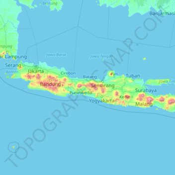
Name: Java topographic map, elevation, terrain.
Location: Java, Indonesia (-8.78042 105.20955 -5.87550 114.60539)
Average elevation: 41 m
Minimum elevation: -2 m
Maximum elevation: 3,329 m
Other topographic maps
Click on a map to view its topography, its elevation and its terrain.
Ciliwung
Mean rainfall reaches 3,125 mm, with a mean annual discharge of 16 m3/s as measured at Ciliwung Ratujaya observation station (231 km2). With such topographical, geological, and hydrological features, the Ciliwung River is often overflowing and inundating parts of Jakarta. The population along the Ciliwung…
Average elevation: 181 m
Sidoluhur
Indonesia > Special Region of Yogyakarta > Sleman Regency > Sidoagung
Average elevation: 120 m
Palangka Raya
Indonesia > Central Kalimantan > Palangka Raya
Palangka Raya borders Gunung Mas Regency to the north, Katingan Regency to the west, and Pulang Pisau Regency to the south and east. The area's soil consists mostly of peat and alluvium in its southern part and podzol on the northern part of the city. Overall, podzol soil dominates the city soil with 218,486…
Average elevation: 10 m
Pangkalpinang
Indonesia > Bangka-Belitung Islands > Pangkalpinang
The city's topography is generally undulating and hilly, with an altitude of 20–50 metres (66–164 ft) above sea level. Hilly areas are primarily in the west and south, including Mount Girimaya (50 metres above sea level) and Tower Hill. A 290-hectare (720-acre) urban forest is in the Old Village area. An…
Average elevation: 20 m