
Rondane National Park topographic map
Interactive map
Click on the map to display elevation.
Rondane National Park
Rondane National Park (Norwegian: Rondane nasjonalpark) is the oldest national park in Norway, having been established on 21 December 1962. The park is located in Innlandet county, in the municipalities of Dovre, Folldal, Sel, Nord-Fron, Sør-Fron, Stor-Elvdal, and Ringebu. The park contains ten peaks above 2,000 metres (6,560 ft), with the highest being Rondeslottet at an altitude of 2,178 m (7,146 ft). The park is an important habitat for herds of wild reindeer.
About this map
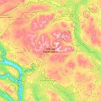
Name: Rondane National Park topographic map, elevation, terrain.
Location: Rondane National Park, Norway (61.68988 9.37878 62.08561 10.19506)
Average elevation: 1,107 m
Minimum elevation: 280 m
Maximum elevation: 2,153 m
Other topographic maps
Click on a map to view its topography, its elevation and its terrain.
Reine
Allers, the largest weekly magazine in Norway, selected Reine as the most beautiful village in Norway in the late 1970s. A photograph over Reine from the mountain Reinebringen (altitude 448 metres (1,470 ft)) has been used for the front page of several tourist brochures and books. In 1999 the painter Ingo…
Average elevation: 58 m