
Mbarara topographic map
Interactive map
Click on the map to display elevation.
Mbarara
Mbarara district consists of one municipality (Mbarara Municipality), and nineteen rural sub-counties, organized into two counties. Mbarara District covers a land area of 1,778.4 square kilometres (686.6 sq mi), with an average elevation of about 1,800 metres (5,900 ft) above sea level. The district receives an average annual rainfall of 1,200 millimetres (47 in). Temperatures range between 17 °C (63 °F) and 30 °C (86 °F).
About this map
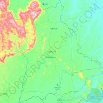
Name: Mbarara topographic map, elevation, terrain.
Location: Mbarara, Western Region, Uganda (-0.63005 30.43807 -0.20569 30.77858)
Average elevation: 1,482 m
Minimum elevation: 1,281 m
Maximum elevation: 2,168 m
Other topographic maps
Click on a map to view its topography, its elevation and its terrain.
Kafu River
Uganda > Nakasongola > Kyajongo
The swamp, out of which River Kafu arises, is also transversed by another river system called River Nkusi. River Nkusi however, arises elsewhere and passes through the said swamp and flows westwards to empty into Lake Albert, along the International border between Uganda and the Democratic Republic of the…
Average elevation: 1,043 m
Mubende
Mubende is approximately 150 kilometres (93 mi), by road, west of Kampala, the capital of Uganda and its largest city. The town is located about 145 kilometres (90 mi) east of the city of Fort Portal along the Mubende–Kyegegwa–Kyenjojo–Fort Portal Road. The geographical coordinates of the town are…
Average elevation: 1,303 m
Kisoro
Kisoro is approximately 76 kilometres (47 mi), by road, west of Kabale, the largest city in the Kigezi sub-region. This is approximately 484 kilometres (301 mi), by road, southwest of Kampala, the capital of Uganda and the country's largest city. Kisoro is east of Rumangabo and the Virunga Mountains in the…
Average elevation: 1,911 m