Geolocate

Mityana topographic map

Interactive map

Click on the map to display elevation.

About this map

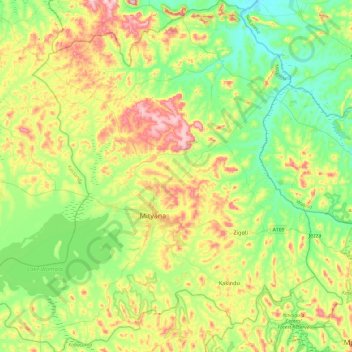
Name: Mityana topographic map, elevation, terrain.

Location: Mityana, Central Region, Uganda (0.21487 31.80205 0.69702 32.26745)

Average elevation: 1,199 m

Minimum elevation: 1,077 m

Maximum elevation: 1,432 m

Other topographic maps

Click on a map to view its topography, its elevation and its terrain.

Buyaga

Uganda > Kagadi

Average elevation: 1,194 m

Kyeema

Uganda > Kyegegwa

Average elevation: 1,308 m

Namakwa

Uganda > Mukono

Average elevation: 1,169 m

Mt. Elgon N.p

Uganda > Kween

Average elevation: 2,882 m

Kalagala

Uganda > Mpigi

Average elevation: 1,202 m

Katooma

Uganda > Kagadi

Average elevation: 1,244 m

Makay

Uganda > Central Region > Kampala

Average elevation: 1,190 m

Panduku

Uganda > Madi Okollo

Average elevation: 672 m

Wetland

Uganda > Otuke

Average elevation: 1,076 m

Isreal-matovu

Uganda > Central Region > Kampala

Average elevation: 1,187 m

Kifuka

Uganda > Rubanda

Average elevation: 1,957 m

Kalinda

Uganda > Nakasongola

Average elevation: 1,049 m

Kakindu

Uganda > Mityana

Average elevation: 1,219 m

Okwongo We

Uganda > Otuke

Average elevation: 1,046 m

Kihura

Uganda > Kyenjojo

Average elevation: 1,317 m

Kiduru Cell

Uganda > Masindi

Average elevation: 1,099 m

Kyarusozi

Uganda > Kyenjojo

Average elevation: 1,456 m

Kakabara

Uganda > Kyegegwa

Average elevation: 1,320 m

Bombo

Uganda > Bulambuli > Bugisa sub-region

Average elevation: 2,022 m

Kayonza

Uganda > Kayunga

Average elevation: 1,063 m

Bombo

Uganda > Mubende

Average elevation: 1,290 m

Luweero

Uganda > Luweero

Average elevation: 1,101 m

Nabingora

Uganda > Mubende

Average elevation: 1,347 m

Kiyuya

Uganda > Mubende

Average elevation: 1,320 m

Buluko

Uganda > Kakumiro

Average elevation: 1,107 m

Mubende

Uganda > Mubende

Mubende is approximately 150 kilometres (93 mi), by road, west of Kampala, the capital of Uganda and its largest city. The town is located about 145 kilometres (90 mi) east of the city of Fort Portal along the Mubende–Kyegegwa–Kyenjojo–Fort Portal Road. The geographical coordinates of the town are…

Average elevation: 1,303 m

Kibisi

Uganda > Kassanda

Average elevation: 1,181 m

Kibanyi

Uganda > Mubende

Average elevation: 1,286 m

Kyenda

Uganda > Kibuku

Average elevation: 1,080 m

Namungo

Uganda > Mityana

Average elevation: 1,150 m

Kafu River

Uganda > Nakasongola > Kyajongo

The swamp, out of which River Kafu arises, is also transversed by another river system called River Nkusi. River Nkusi however, arises elsewhere and passes through the said swamp and flows westwards to empty into Lake Albert, along the International border between Uganda and the Democratic Republic of the…

Average elevation: 1,043 m

Buwunde-bamba

Uganda > Masaka

Average elevation: 1,206 m

Myanzi

Uganda > Kassanda

Average elevation: 1,194 m

Luwero

Uganda > Bugiri

Average elevation: 1,138 m

Ntwetwe

Uganda > Kyankwanzi

Average elevation: 1,110 m

Madudu

Uganda > Mubende

Average elevation: 1,237 m

Mbaale

Uganda > Jinja

Average elevation: 1,184 m

Dwaliro

Uganda > Kassanda

Average elevation: 1,215 m

Kyenda

Uganda > Jinja

Average elevation: 1,129 m

Bukuya

Uganda > Kassanda

Average elevation: 1,173 m

Water

Uganda > Wakiso > Entebbe City

Average elevation: 1,134 m

Mutara

Uganda > Rukungiri

Average elevation: 1,657 m

Buwagga

Uganda > Buikwe

Average elevation: 1,226 m

Kigezi

Uganda > Mbale > Bugisa sub-region

Average elevation: 1,748 m

Kuluba

Uganda > Koboko

Average elevation: 1,245 m

Nabakazi

Uganda > Mubende

Average elevation: 1,186 m

Rushere

Uganda > Kiruhura

Average elevation: 1,342 m

Kyenda

Uganda > Mubende

Average elevation: 1,272 m

Luwero

Uganda > Buvuma

Average elevation: 1,134 m

Kasiiso

Uganda > Luweero

Average elevation: 1,105 m

Kiwira

Uganda > Bugisa sub-region > Mbale City

Average elevation: 1,484 m

Kikyusa

Uganda > Luweero

Average elevation: 1,096 m

Lake Kasenda

Uganda > Kabarole > Nyabweya

Average elevation: 1,253 m

Lwamugolode

Uganda > Nakasongola

Average elevation: 1,062 m

Lima

Uganda > Arua

Average elevation: 1,449 m

Galilaya

Uganda > Kamwenge

Average elevation: 1,266 m

Omel .a.

Uganda > Gulu

Average elevation: 941 m

Kasambya

Uganda > Wakiso

Average elevation: 1,130 m

Namasagali

Uganda > Ngora

Average elevation: 1,097 m

Kagoye

Uganda > Kayunga

Average elevation: 1,077 m

Budzibwera

Uganda > Luweero

Average elevation: 1,084 m

leak

Uganda > Kanungu > Bugonje > Bugongi

Average elevation: 1,363 m

Baskerville

Uganda > Buikwe

Average elevation: 1,230 m

Swamp

Uganda > Masaka

Average elevation: 1,139 m

Buzindere

Uganda > Wakiso > Buzindere

Average elevation: 1,143 m

Mount Morungole

Uganda > Kaabong

Average elevation: 2,388 m

Kavango

Uganda > Nebbi

Average elevation: 620 m

Kinanga

Uganda > Yumbe > Kinanga

Average elevation: 898 m

Phillip Peak

Uganda > Kasese

Average elevation: 4,353 m

Middle Portal

Uganda > Kasese

Average elevation: 3,946 m

Balinga

Uganda > Amuria > Balinga

Average elevation: 1,072 m

Kamonyi

Uganda > Kisoro > Kamonyi

Average elevation: 1,898 m

Bulimba

Uganda > Butaleja > Bulimba

Average elevation: 1,078 m

Kisoro

Uganda > Kisoro > Cyanika

Kisoro is approximately 76 kilometres (47 mi), by road, west of Kabale, the largest city in the Kigezi sub-region. This is approximately 484 kilometres (301 mi), by road, southwest of Kampala, the capital of Uganda and the country's largest city. Kisoro is east of Rumangabo and the Virunga Mountains in the…

Average elevation: 1,911 m